Saturday, December 31, 2005

Accident of the Week

This week, we encounter a report of a student pilot on a solo cross-country who decided that landing on a frozen lake would be a -- um, um, um -- "good" idea. Obviously not.
NTSB Identification: CHI06CA052.
The docket is stored in the Docket Management System (DMS). Please contact Records Management Division
14 CFR Part 91: General Aviation
Accident occurred Monday, December 26, 2005 in Pelican Lake, WI
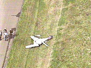
Aircraft: Cessna 152, registration: N6085M
Injuries: 1 Uninjured.

On December 26, 2005, about 1230 central standard time, a Cessna 152, N6085M, piloted by a student pilot, sustained substantial damage on impact with the snow and ice on Pelican Lake, Wisconsin. The solo cross country instructional flight was operating under 14 Code of Federal Regulations Part 91. Visual meteorological conditions prevailed at the time of the accident. No flight plan was on file. The pilot reported no injuries. The flight originated from the Waukesha County Airport, near Waukesha, Wisconsin, and was en route to the Rhinelander-Oneida County Airport, near Rhinelander, Wisconsin, at the time of the accident.

The pilot's accident report, in part, stated:

On the 26th day of December at 1230 AM central time I
was on a solo cross country flight from Waukesha to
Rhinelander WI. While in route I made the decision to
land on Pelican Lake located about 20 mi south of
Rhinelander WI. I made a few low passes over the lake
to observe the surface conditions. I could see that
there was only a few inches of snow on the lake and
surface seemed to be flat (no snow drifting or ice
heaves) so I set myself up for a soft field landing
configuration. Upon main gear touching down the
gear was restricted and pulled the nose of the aircraft
to the ground (ice) slid about 25 yards then settled
back onto main gear.

The pilot's safety recommendation, in part, stated:

This accident could have been prevented if I would have
just stuck to my flight plan and [federal aviation
regulations]. I realize that I made a very bad decision
to land on the lake and have learned greatly from it.

The best thing this pilot did was file an ASRS form.

Now, maybe the IFR Pilot has missed something, but his private pilot training didn't include any off-airport landings. Did any of yours?

Happy New Year!

Ice!

"78S, turn left, 200, track the localizer."

JP and the IFR Pilot were smack dab in the clag. We took off from the home base, expecting to fly a couple of approaches and maybe get some actual. Did we ever!

Shortly after departing the home base, we called CAK Approach with our requests (ILS 19 at CAK, ILS 24 at BKL, VOR at 1G1). Before we knew it, we were MVFR and patiently awaiting our squawk code and an IFR clearance. Conditions had rapidly dropped at CAK, and the climb from 2500 to 3000 put us deep in the clouds. The IFR Pilot was doing the flying and JP was keeping an eye on things. This, of course, was the first time that the IFR Pilot had been in actual conditions since July's final leg home from Alaska. Well, in for a penny, in for a pound.

Approach advised that ILS 23 was active and inquired if we specifically wanted ILS 19. We advised that we'd take the ILS 23.

As we flew outbound past EGGII and awaited our turn inbound to intercept the localizer, the ice started to accumulate. At first, it was just a very, very light rime. But after Approach instructed us to climb and maintain 3200, it started to accumulate a bit more quickly. At that point, the IFR Pilot advised approach that we'd be canceling the rest of the requested approaches and landing at CAK.

Six miles from EGGII, we received the rather strange instruction of "turn left, 200, track the localizer." The IFR Pilot wasn't 100% sure what the controller meant by this. It clearly wasn't a clearance for the procedure itself. I interpreted it as an instruction to get established on the final approach course (234 degrees), but not a clearance to execute the procedure.

That's when things started getting a bit hairy. The IFR Pilot blew through the localizer and had to make some S turns to get back on it. He was pretty quiet, but I think JP was just a tad bit nervous watching the S turns, which caused some slight altitude deviations. Never more than 100 feet, but hey, in the wrong place at the wrong time, 100 feet could be deadly.

Shortly, we were cleared for the approach and turned over to the tower controller, who cleared us for the option. At that point, there was quite a bit of rime on the wing and the windscreen wasn't looking so clear either. The IFR Pilot advised we'd be making a full stop.

We broke out at about 2500 and a bit left of the runway. Not knowing exactly how much ice we had picked up, the IFR Pilot elected to keep the speed up and make a no flap landing. After all, Runway 23 is 7597' long, so there's plenty of room to slow it down. A left turn and back taxi on the intersecting runway, then a right turn on Taxiway Charley and we were off to McKinley Aviation for a manual deicing operation (i.e., poke the ice off and dry with paper towels purloined from the rest room. Hey, they charged us $10 for sitting on the ramp, so at least we got something for our money...).

JP did the flight home. Instead of stepping up to the plate and filing for an approach to the airport next to home base, he just flew it VFR at 2500. Lazy, lazy, lazy.

A half hour in the clag for the IFR Pilot, with icing. Talk about back in the saddle.

Thursday, December 29, 2005

Foiled Again

The IFR Pilot was once again scheduled for an Angel Flight, this time from CAK to AZO. JP was to co-pilot. Since the recent Angel Flights announced in advance here ended up being scrubbed, no announcement was made of this one, in hopes that the Weather Gods would favor us this time.

Wrong.

This afternoon's TAFs for CAK and AZO were as follows:

KCAK 292013Z 292018 31010KT 6SM -RA BR OVC004
TEMPO 2024 1 1/2SM -RASN BR OVC007
FM0000 31008KT 3SM -DZ BR OVC006
FM0200 31008KT 5SM BR OVC010
FM0500 30006KT 5SM BR OVC015
FM1000 VRB04KT 4SM BR OVC010
FM1400 10006KT 5SM BR OVC015
KAZO 291721Z 291818 33010KT P6SM OVC012
FM2100 32006KT P6SM OVC018
FM0000 00000KT P6SM OVC012
FM0600 00000KT 4SM BR OVC009
FM1200 00000KT 4SM BR OVC004
FM1500 12006KT 4SM BR OVC004
Departure was scheduled for 1500 UTC tomorrow, with arrival in AZO roughly 1:40 later. In deference to the patients, so they could make alternate arrangements before the proverbial eleventh hour, the IFR Pilot decided to cancel. Also, the pilot of leg #1 wasn't sure he was going to be able to get out anyway, due to low icing levels between BWI and CAK, so that made it easier to say "no go."

Sure, a 400 foot ceiling is double the minimums at AZO (which has the standard 200' DH). But that's pretty low, with no guarantee that conditions would be trending toward the better. More importantly, that means taking off for the return flight into extremely low conditions, well below the IFR Pilot's personal minimum of a 1000' ceiling for takeoff.

In addition, the tower at AZO isn't open all the time. The ILS 35 is noted that when the tower is closed, you must use the altimeter setting from KSBN. But, that raises the DH to 410. So, if the tower experiences a power failure (or is otherwise closed for some aberrant reason) and we're forced to use the South Bend altimeter and the forecast ceiling materializes, we're SOL from the get-go.

All in all, that's a recipe for a scrubbed flight. Again.

Hopefully, the patients are able to catch a flight via Southwest. Perhaps the IFR Pilot will spend Friday getting ready for multi-engine training, which will be here in a couple weeks! Stay tuned.

Friday, December 23, 2005

Accident of the Week

This report of an accident in Hawaii is another of those "good weather, what the heck happened" scenarios. The report doesn't provide any information about the condition of the plane following the wreck, and there's no report of any contact by the pilot with ATC concerning his status.
NTSB Identification: LAX06FA059
14 CFR Part 91: General Aviation
Accident occurred Thursday, December 15, 2005 in Hana, HI
Aircraft: Cessna 172S, registration: N542SP
Injuries: 1 Fatal.

This is preliminary information, subject to change, and may contain errors. Any errors in this report will be corrected when the final report has been completed.

On December 15, 2005 at 1550 Hawaiian standard time, a Cessna 172S, N542SP, collided with mountainous terrain under unknown circumstances approximately 3 nautical miles southwest of Hana Airport, Hana, Hawaii. Maui Aviators, LLC, who was also the registered owner of the rental airplane, was operating it under the provisions of 14 CFR Part 91. The commercial pilot, the sole occupant, sustained fatal injuries; the airplane was destroyed. Visual meteorological conditions prevailed and no flight plan was filed. The pilot originally departed from Kahului Airport, Kahului, Hawaii, at 1230, and was destined for Hana. He planned to return to Kahului later that afternoon.

A local helicopter pilot was flying in the area of the accident site, which was located at an elevation of 2,400 feet mean sea level on Mount Haleakala, on a terrain slope of approximately 75 degrees. He noted smoke about 100 yards from where he had been working. He flew to the site within 30 seconds and saw a white fuselage and what appeared to be a Cessna 172. He searched for survivors and then notified his ground crew who radioed for assistance to the local fire department helicopter. According to the pilot, based on the accident site it appeared that the airplane was flying in a west-southwest direction prior to impact. The pilot reported clear skies with little wind and no turbulence. Prior to seeing the fire, the pilot did not see or hear the airplane approach the vicinity of the accident site.

Records obtained from Maui Aviators, LLC, showed that the pilot completed a company checkout in the airplane on November 26.

The National Transportation Safety Board investigator interviewed the certified flight instructor (CFI) that performed the pilot's checkout. The pilot reported that he was visiting the area from Salt Lake City, Utah, and he wanted to tour the island. During the checkout flight, they flew toward the Hana airport but did not land there. Various maneuvers were completed and a total of seven landings were logged at the Kahului airport. The length of flight was 1.3 hours, in addition to 1 hour of ground instruction. On December 15, the pilot arrived 2 hours early for his flight. He had the airplane scheduled from 1200 until 1700 on December 15, and he also had it scheduled from 1200 until 1700 the following day.

The airplane was last fueled on December 14, 2005, at 1613. The airplane's fuel tanks were topped off with 9.24 gallons of fuel and were full upon the pilot's departure from Kahului airport.
The pilot held a commercial certificate, and it appears that he underwent a thorough checkout. He's from the Western U.S., so flying in rugged terrain should have been more comfortable for him than a flatland flyer from other parts of the States. He had been airborne about 3 hours, which is well within the endurance of a fully-fueled 172SP. All in all, another mysterious crash.

Monday, December 19, 2005

Accident of the (Last) Week

Unfortunately -- or, perhaps, fortunately -- there weren't too many new postings on the NTSB's web site last week to pick something to write about. And the IFR Pilot couldn't come up with any good ideas to go searching for an older report.

But today, this one showed up. It seemed timely, given that the IFR Pilot just flew with a new instructor. I think we'll file this one under the Department of "You Better Chose Your CFI Very, Very Carefully." John, I expect better treatment in March...

NTSB Identification: SEA06CA023
14 CFR Part 91: General Aviation
Accident occurred Saturday, December 03, 2005 in Sandpoint, ID
Aircraft: Diamond Aircraft Industries HK 36 TTC, registration: N543MD
Injuries: 2 Uninjured.

On December 3, 2005, about 1600 Pacific standard time, a Diamond Aircraft Industries HK 36 TTC, N543MD powered glider, registered to and operated by the pilot as a 14 CFR Part 91 instructional flight, collided with a tractor during takeoff from a private airstrip near Sandpoint, Idaho. Visual meteorological conditions prevailed at the time and no flight plan was filed. The glider was substantially damaged and the private pilot owner and flight instructor were not injured. The flight departed from Sandpoint Airport about 30 minutes prior to the accident.

During a telephone interview and subsequent written statement, the pilot stated that they had been practicing short field approaches at the Sandpoint Airport, then decided to go to the owner's property where he had a private airstrip. The pilot stated that the flight instructor was flying the glider, making a low approach over the airstrip when he unexpectedly decided to land. The airspeed was too high to stop on the remaining runway which was covered with compacted snow. After rolling about 300 feet, the flight instructor applied full throttle for the takeoff. The pilot pointed out the power lines beyond the end of the runway, and the flight instructor stated that they would fly under them. At this time the left wing struck a tractor that was positioned at the end of the airstrip. The wing separated from the airframe and the glider spun around, coming to rest.

The pilot stated that there was no mechanical failure or malfunction with the glider at the time of the accident.

Good News, Bad News

Well, it's not quite along the lines of John's latest post involving the old "good news, bad news" conundrum, but here goes.

Saturday's Angel Flight was cancelled. The pilot of the third leg pulled out and donated some miles in exchange for a ticket on Southwest for the patient. That inspired a change of plans for all, because those miles were able to get her a ticket the whole way home from Cleveland. Which was great, because the home base runway might have been useable for departure, but not for landing (1/2 inch of ice; poor to nil braking action).

Sunday involved quite a workout. Runway conditions having improved, the IFR Pilot scheduled with a new instructor, JD, to get an instrument refresher flight (and to check out possible instructors for the commercial.) JP tagged along in the backseat, and was pretty mellow acting as the peanut gallery.

The instructor started up with ground school questions before we could even get 78S turned around on the iced-up hangar ramp. Stumped the IFR Pilot with "When are you established on an approach?" Correct answer - needle movement on an ILS, +/- 2 dots on a VOR approach. Yeah, I knew that. Really, I did. I swear.

Shortly after takeoff, we flew into some low visibility conditions with blowing snow. A local IFR clearance (a/k/a pop-up clearance) ensued so that we could make some approaches: VOR-A into 29G, ILS 23 at CAK, LOC 25 at AKR, and VOR 28 into BJJ. JD's overall assessment was that I was still allowed to refer to myself at the IFR Pilot.

Recap: The LOC approach was flawless. ("Like a coupled approach in an airliner," was JD's professional assessment.) The ILS was acceptable. The two VOR approaches were, in my estimation, marginal, though JD said I'd still pass the IFR checkride. Going into 29G, the needle almost went full scale. Going into BJJ, the IFR Pilot had set the OBS wrong by 20 degrees. We could tell by the GPS that we had blown through the final approach course, which was confirmed when ATC advised us of such and gave us a vector to reintercept. "That mistake will get you killed," JD sagely advised. No kidding.

At one point, JP was kind enough to hand me the reminder note from his training with JD: "Have you identified the navaid?" You can guess what was happening to prompt that.

After the final approach and a steep descent to land at BJJ, a bit of marginal VFR flying got us back to home base in one piece. A nice landing ensued. All that remained was to write a check to JD for the 1.7 hour workout.

Putting 78S away required a bit of pushing, shoving, and grunting. Too much ice on the hangar ramp. JP and I managed to get her in the hangar without damaging anything.

Stay tuned - JP, M, and the IFR Pilot are heading here for multi-engine training in January. Clearly, this will produce multiple entries bound to keep y'all glued to your CRTs.

Friday, December 16, 2005

Could It Be

That the IFR Pilot will actually get to fly an Angel Flight mission tomorrow?

JP and I are scheduled to fly a woman that underwent brain surgery from BKL to MQJ. Weather might be a bit dicey at the outset, but I think we can handle that. The bigger concern is the runway at home base, which apparently is more like a hockey rink than a runway. Landing upon return is going to be an adventure. Stay tuned for an update.

For Some Reason...

Blue Angel #7 is parked on the ramp at BKL, visible from the IFR Pilot's office.

There isn't another Blue Angel in sight. Probably won't be until Labor Day weekend at the earliest.

What gives, people? (I suspect they're planning logistics for the show.)

Wednesday, December 14, 2005

Oops...

(from www.ohio.com)

Plane flips during landing in Medina

SHARON TWP.: A single-engine Lancair 235 airplane attempting to land Tuesday at the Medina Municipal Airport on state Route 18 slid off a runway and flipped over around 2 p.m.

Ohio State Patrol Sgt. Michael Combs said the pilot, a 37-year-old Akron man, was not hurt. The pilot's name has not been released.

Combs said the aircraft left Cobb County Airport near Atlanta around 11 a.m. Tuesday morning en route to Medina.

The Federal Aviation Administration and Ohio State Patrol are investigating to determine the cause of the crash.

(from www.newsnet5.com)

Plane Slides Off Runway, Crashes At Medina Airport

No One Injured In Crash

POSTED: 4:30 pm EST December 13, 2005

Icy conditions on a Medina Municipal Airport runway caused a plane to slide off and flip over while landing Tuesday afternoon.

The accident occurred at about 2:15 p.m. Tuesday.

The pilot of the Lancair 235 plane said the ice and snow caused him to slide off the side of the runway. The propeller hit the ground, flipping the plane over onto its top.

The pilot was able to exit the plane safely and was not injured.The crash scene is still being cleared.

The Federal Aviation Administration is investigating.
Warning -- Media Rant: What's again irritating about these is that if it had been a car accident, where no one was hurt, would it have even mentioned a news report? Or this stupid photo on newsnet5.com, which shows, well, I don't know what it's supposed to be showing!

Sunday, December 11, 2005

Test Results Are In....


What Airplane Are You?


You are a BEECHCRAFT B58. You enjoy the simple enjoyments in life. You're not afraid of taking a few chances, but would prefer to live somewhat more on the safe side. You enjoy simple luxury, travel, and conversation. A day soaring above the clouds in one of these is your idea of a fun, safe, and enjoyable flight.

Take this quiz!


Friday, December 09, 2005

Accident of the Week

This week's Accident of the week involves the mysterious crash of a Beech Baron that was on final approach to KACK's ILS 6. The IFR Pilot and IFR Pilot Dad visited Nantucket during the Great Flying Vacation of '04, so this one brought back memories.

Looks like they may never recover the wreckage, and so NTSB may not ever have a probable cause determination. Always troubling when radar shows an aircraft within one mile of the airport and things go awry. Condoloences to the family and friends of the accident pilot.
NTSB Identification: NYC06FA040
14 CFR Part 91: General Aviation
Accident occurred Thursday, December 01, 2005 in Nantucket, MA
Aircraft: Beech B-55, registration: N64PW
Injuries: 1 Fatal.

This is preliminary information, subject to change, and may contain errors. Any errors in this report will be corrected when the final report has been completed.

On December 1, 2005, at 1644 eastern standard time, a Beech B-55, N64PW, was presumed destroyed during collision with water, while on approach to Nantucket Memorial Airport (ACK), Nantucket, Massachusetts. The certificated commercial pilot was not located, and presumed to be fatally injured. Instrument meteorological conditions prevailed for the flight that departed Teterboro Airport (TEB), Teterboro, New Jersey, about 1530. An instrument flight rules (IFR) flight plan was filed for the personal flight conducted under 14 CFR Part 91.

Earlier in the day, the pilot flew his son to TEB, dropped him off, and refueled the airplane to capacity. The pilot then obtained a weather briefing from a flight service station (FSS), and filed an IFR flight plan for the return flight to ACK. According to preliminary information from the Federal Aviation Administration (FAA), the flight proceeded to the ACK area, and Air Traffic Control (ATC) cleared the pilot for the ILS Runway 6 approach. The pilot acknowledged the clearance and initiated the approach. Radar contact and radio communication were lost when the airplane was approximately 1 mile from the airport, about 200 feet msl. ATC did not receive a distress call from the pilot.

A search was initiated by the United States Coast Guard, and subsequently terminated about 1315 on December 2, 2005. As of the publication of this report, the pilot and main wreckage were not located. However, an approximate 3-foot by 5-foot section of airplane cabin roof washed up on the south shore of Nantucket, and was recovered by the Nantucket Police Department. Examination of the roof by a Safety Board investigator and the pilot's family confirmed that it was from the accident airplane.

The pilot's logbook and aircraft logbooks were reported to be in the accident airplane, and also not recovered. The pilot held a commercial pilot certificate with ratings for single engine land, single engine sea, multiengine land, and instrument airplane. The pilot also held a certified flight instructor certificate. The pilot's most recent FAA third class medical certificate was issued on February 14, 2005. At that time, he reported a total flight experience of 5,000 hours. In addition, the pilot's family stated that he had accumulated approximately 1,000 total hours of actual instrument flight time, and 400 hours in the same make and model as the accident airplane. The pilot had flown about 15 hours within the 90 days preceding the accident; of which, about 3 hours were in actual instrument conditions.

According to the pilot's son, the pilot did not exhibit any abnormal behavior on the day of the accident, nor did he complain of any ailments. The pilot's son further stated that the airplane was operated about 250 hours during the prior year, with no difficulties noted. The airplane was equipped with new engines during 2002, and the last annual inspection was completed during April 2005.

The recorded weather at ACK, at 1653, was: wind from 020 degrees at 17 knots; visibility 2 1/2 miles in light rain and mist; overcast ceiling at 400 feet; temperature 45 degrees F; dew point 42 degrees F; altimeter 29.65 inches Hg.

Thursday, December 08, 2005

Kudos & Congrats...

...to one of the IFR Pilot's partners, JP, who passed his instrument checkride today. Excellent job, dude! Especially since you didn't bust the ride, like the IFR Pilot did. (In my defense, it was incredibly windy that day and so I had a "wee bit" of trouble getting established in the VOR hold. I nailed it a couple days later, but remain humble as a result.) According to this screen grab from Flight Aware, the flight portion of JP's ride was pretty quick and efficient:

Time to plan a $100 hamburger run through the clouds. And now you need to sign up with Angel Flight too.

Monday, December 05, 2005

Return to Flight

*drumroll, please*

On Saturday, the IFR Pilot returned to flight. A magnificent 1.7 hours total, including 3 approaches, 4 landings, .9 under the hood, and some time safety piloting for JP, who takes his IFR checkride on Wednesday.

Popped over to MFD to fly the ILS 32. Did that twice. Both times were somewhat pitiful, and certainly not up to PTS standards. Chasing needles the entire time, but I suppose that's to be expected after a couple months of not flying at all. When JP flew the same approach -- from the right seat, no less -- he pretty much put me to shame. But, the IFR Pilot was pretty sharp too when he was just a couple days away from facing the Dreaded Designated Examiner.

After a low approach, the IFR Pilot reclaimed the Pilot Flying duties for the VOR 10 into BJJ. We were cleared direct PTATO, one of my favorite local intersection names. If you look at the plate, you'll see that this is not an approach you'd really want to fly in actual without the GPS as backup -- or better yet, fly the GPS overlay. At PTATO, you're about 38 miles from the BSV VOR and so the movement of the needle is pretty slow. Even at the MAP, you're 28 miles from the VOR.

JP said that the IFR Pilot busted altitude, but I countered that the airport was in sight before the descent below MDA! A smooth landing ensued, giving the IFR Pilot enough confidence to fly 78S back to home base's 2350' by 35' runway.

Both of this week's Angel Flights cancelled, so the IFR Pilot is looking for new excuses to go flying. Anyone got any new excuses that will pass muster with the boss?

Friday, December 02, 2005

Accident of the Week

Looking forward to next week's scheduled Angel Flights, this week's Accident of the Week involves the mysterious crash of a Cessna Cardinal that was on an Angel Flight mission. The fatal accident occurred over two years ago, but the NTSB still hasn't released a probable cause finding.

NTSB Identification: LAX04FA042
14 CFR Part 91: General Aviation
Accident occurred Thursday, November 13, 2003 in BLK CANYON CITY, AZ
Aircraft: Cessna 177RG, registration: N431DL
Injuries: 1 Fatal.

This is preliminary information, subject to change, and may contain errors. Any errors in this report will be corrected when the final report has been completed.

On November 13, 2003, about 0930 mountain standard time, a Cessna 177RG, N431DL, collided with terrain after reporting engine problems 12 miles east of Black Canyon City, Arizona. The airline transport pilot/owner operated the airplane under the provisions of 14 CFR Part 91. The airplane was destroyed. The pilot, the sole occupant, sustained fatal injuries. The personal cross-country flight departed Flagstaff/Pulliam Airport (FLG), Flagstaff, Arizona, about 0800, en route to the Phoenix-Deer Valley Airport (DVT), Phoenix, Arizona. Day visual meteorological conditions prevailed, and an instrument flight rules (IFR) flight plan had been filed. The primary wreckage was at 34 degrees 06.330 minutes north latitude and 111 degrees 57.675 minutes west longitude.

The pilot volunteered for the Angel Flight organization. The purpose of the flight was to pickup a person in DVT and transport them to the Burbank-Glendale-Pasadena Airport (BUR), Burbank, California.

According to radio communications, the pilot checked in with Phoenix Terminal Radar Control (PHX TRACON). He then reported that he had engine problems and needed vectors to the closest airport. A PHX TRACON controller vectored him to the Sky Ranch at Carefree (18AZ), Carefree, Arizona. The pilot radioed that he was losing altitude at 600 feet per minute (fpm). He then radioed that he was losing 800 fpm. PHX TRACON lost radar contact at 4,800 feet, and radio contact shortly thereafter.

The accident site was located in a Bureau of Land Management (BLM) land area at 3,700 feet. Juniper trees, Cholla, various other cacti, and other vegetation indicative of Northern Arizona surrounded the area. The accident site was in a valley with a 10-degree upslope. The airplane was parallel with the terrain. The debris path was along a magnetic bearing of 200 degrees. The first identified point of contact (FPIC) was a tree, 37 feet from the main wreckage. An impact mark was located at 27 feet from the main wreckage. The length of the airplane was 24.6 feet.

Visual examination of the engine revealed no obvious preimpact anomalies. There were no oil or fuel stains on the external part of the engine. Investigators removed the top spark plugs, which were gray in color. The coloration corresponded to normal operation according to the Champion Aviation Check-A-Plug AV-27 Chart. A borescope inspection revealed no mechanical deformation on the valves, cylinder walls, or internal cylinder head. Investigators established engine control continuity from the cockpit to the engine.

The propeller remained attached to the engine at the propeller hub. One blade was straight with no chordwise or longitudinal scoring. The other blade was bowed about midspan with a nick noted on the trailing edge of the blade. Longitudinal scoring was on the tip of the blade.

Investigators established flight control continuity from the tail to the aft cabin pulleys. The cables were inaccessible from the aft cabin to the cockpit. They established flight control continuity in the wings from the left wing bellcrank to the right wing bellcrank.

Thank heavens this occurred on the pickup leg, not the passenger leg. The report gives no hints at all as to what might have happened here. There's no mention of weather, so we're probably safe in assuing that it was VFR, maybe even CAVU. Obvious mechanical issues aren't hinted at either. We'll just have to keep waiting to see what the NTSB has to say when it issues its report.

Thursday, December 01, 2005

Trying again

The IFR Pilot is scheduled for two Angel Flights next week. One is MFD to UGN, the other is EYE to BKL. Weather Gods, please forgive the IFR Pilot and his sins, and favor us with conditions unfavorable for icing, would ya? Pretty please.

Friday, November 25, 2005

Accident of the Week

Tonight's Accident of the Week involves the lucky pilot of a Piper Arrow that surrived a crash into some trees following a loss of engine power. Reminds the IFR Pilot of his troubles during the Great Alaska Flying Adventure (tm)...
NTSB Identification: MIA06LA019
14 CFR Part 91: General Aviation
Accident occurred Tuesday, November 15, 2005 in Heathrow, FL
Aircraft: Piper PA-28R-180, registration: N7453J
Injuries: 2 Minor.

This is preliminary information, subject to change, and may contain errors. Any errors in this report will be corrected when the final report has been completed.

On November 15, 2005, about 2053 eastern standard time, a Piper PA-28R-180, N7453J, registered to Magic Interiors, collided with trees, the roof of a house, then the ground during a forced landing in a residential area near Heathrow, Florida. Visual meteorological conditions prevailed at the time and no flight plan was filed for the 14 CFR Part 91 personal, local flight from Orlando Sanford International Airport (KSFB). The airplane was substantially damaged and the commercial-rated pilot and one passenger sustained minor injuries. The flight originated about 1923, from Orlando Sanford International Airport.

The pilot stated that during his preflight inspection of the airplane he noted the fuel level in the left and right fuel tanks were nearly full, and slightly above the tab, respectively. No contaminants were noted when examining each fuel tank and the fuel strainer. The engine was started with the fuel selector positioned to the right tank, and after engine start, he contacted air traffic control (ATC) and was cleared to taxi to runway 9R. He repositioned the fuel selector to the left tank and performed an engine run-up with no discrepancies reported. He was cleared for takeoff and remained in the traffic pattern for runway 9R where he performed 3 or 4 touch-and-go landings. After the last landing he exited the traffic pattern to the west and proceeded to Leesburg Regional Airport where he performed a full-stop landing on runway 31. He taxied back to runway 31, departed, and climbed to 1,000 feet. He exited the traffic pattern to the east and climbed to 2,000 feet where he reduced the throttle control to 23 inches manifold pressure and the propeller to 2,400 rpm. He also leaned the fuel/air ratio, and proceeded towards KSFB. When the flight was 9.8 miles from KSFB and near Orlando Class B airspace, he established contact with KSFB ATCT. The controller advised him to contact them when the flight was 3 miles away but the controller contacted him before then and advised of nearby traffic. He descended to 1,500 feet and approximately 1 minute later, the engine went to idle and was operating rough but did not quit. He immediately looked at the oil pressure and temperature gauges and noted both indications were in the green arc. He did not recall looking at the tachometer or the fuel flow gauge at the time of the loss of engine power.

The pilot further stated he could not recall the sequence but he "worked" the throttle control which only momentarily corrected the loss of engine power. The engine did hesitate/sputter each time he increased the throttle control. He placed the mixture control to full rich, and verified the auxiliary fuel pump was in the "on" position, and the fuel selector was on the left tank position. The fuel pump and fuel selector had been unchanged from the moment of takeoff at KSFB. He repositioned the fuel selector to the right tank which had no affect, and verified the ignition switch was in the "both" position; he did not check the magnetos. He trimmed the airplane to maintain 80 mph, and looked for a place to land. He saw I-4, but knew because of his altitude that was not an option. At 500 feet he observed lights and saw a small road in a community that was located to his left. He reported that the landing gear extended automatically which occurred because of a decrease in engine rpm, and headed towards the road. He was committed to a landing on the road and began a turn to line up parallel. Looking to the side of the airplane as he turned, he saw a tree dead ahead covered by the darkness. He banked to avoid the tree, but knew impact with the tree would occur. The airplane impacted trees, he closed his eyes, and could not recall the ground impact. He and the passenger unbelted their seatbelts, and exited the airplane; he experienced no difficulty exiting the airplane.

Preliminary examination of the accident site by an FAA airworthiness inspector revealed both wings were separated at the wing root; the right wing remained suspended in a tree. Fuel leakage was noted from the left fuel tank which was on the ground. The airplane was recovered for further examination.
It will be interesting to see what the NTSB's determination of the probable cause of this accident is. From the report, it sounds like the pilot did all that he should have, including switching from the left tank to the right tank, with no change in engine performance. We'll keep an eye out for the probable cause determination.

The local paper's article on the accident provides some additional details about the crash.

No Joy

Restored to flight status, the IFR Pilot decided to go fly 78S today, in preparation for Monday's Angel Flight. JP agreed to co-pilot so that some instrument flying could be done.

Mother Nature crushed that dream, thankyouverymuch. The runway at 15G was pretty well iced over, and the Weather Briefer advised that the latest report of braking action was "nil." There goes that plan. Well, at least the GPS chip got updated, and the LP tank was refilled.

On arriving home, the IFR Pilot received a voice mail message that Monday's flight was cancelled. Seems the patient's insurer didn't way to pay for treatment in Chicago...

Wednesday, November 23, 2005

Back In Business, Baby!!!

Best flying-related news the IFR Pilot has received in the last two months: Having an ulcer is not a condition that must be immediately reported to the FAA. As long as the Gastro Doc has cleared a return to normal activity levels (which he has as to the IFR Pilot), a pilot can resume flying. The paperwork drill about endoscopic evidence of healing only comes into play when it's time to renew a medical. Since the IFR Pilot doesn't have to do that for another 2 years, it's back to normal flight ops.

To celebrate, and assuming Mother Nature gets on board, it's an Angel Flight from MDW to CAK on Monday. JP's coming along, just in case. The IFR Pilot's mixed it up with the Big Iron at MDW before, so it should be no problem. But, some practice flights between now and then might be in order. Which explains why we're expecting 12" of snow between now and Friday morning...

But John, we're still going flying in March when I come to SFO.

Here She Is

As promised, a photo of the IFR Pilot and his paramour:

Tuesday, November 22, 2005

Endoscope Done

Today, the IFR Pilot willingly allowed the doctor to shove a camera down his throat into his stomach to take pictures. That's right, boys and girls, the follow-up endoscope was done. Please note that the doctor previously told the IFR Pilot he was healed and didn't need this procedure. But, per the FAA's Guide for Aviation Medical Examiners, the IFR Pilot needs "Radiographic or endoscopic evidence that the ulcer is healed" in order to reclaim his medical.

The only question now is whether the IFR Pilot will be required to finish out the six-month period of stability normally required after an ulcer with a history of bleeding. Mine are fully healed and I've finished the required regimen of medication. So, let's hope that's enough to get back to PIC status. I'll be calling AOPA tomorrow for some help.


In the meantime, JP and I are going flying on Friday in 78S if Momma Nature cooperates. Will be nice to get back to flying her, that's fo' shizzle, my nizzle.

Monday, November 21, 2005

My Paramour

On Saturday, the IFR Pilot broke the vow of monogamy to 78S. A client, TC, owns a certified Lancair Columbia 300, N269GB. He's been itching to take the IFR Pilot flying in it since March.

The sun, moons, stars, and the rest of the universe finally aligned, and we met to go flying on an unbelievably beautiful mid-November day in our neck of the woods. The IFR Pilot dragged along one of 78S's co-owners, MS.

We launched out of 1G5, bound for the ever-popular Flying Turtle Cafe at MFD. The IFR Pilot had the right seat, and did the flying, with TC handling throttle, prop, and communications, and adding a little help for the touchdown.

9GB has a side-stick, and this was the IFR Pilot's first experience with one. It seemed fairly natural, and was certainly wonderful to have the panel in front of you clear of a yoke. Having done some flight simming with a joystick helped, although the physical force required to manipulate the stick reminded you that this wasn't just a simluation.

Final approach speed was 90 knots, and unlike in a Cessna, you drive the Lancair all the way to the ground, with a last minute flare. After 500+ landings in the child of Clyde Cessna (and a half dozen in an Arrow), the speed and sight picture were dramatically different.

Speaking of sight pictures, 9GB is equipped with an Apollo GPS driving two MX 20 MFDs. The upper MFD displays VFR Sectionals, while the lower MFD displays IFR en-route charts and Jeppesen approach plates. MS flew the GPS 27 on our return, and it was pretty slick to see the approach being displayed on the MFD as we flew it.

All in all, anytime that TC wants a co-pilot, the IFR Pilot's there. He says he may be selling her in a couple of years, as he's looking to step up to a D-Jet. The IFR Pilot has decided to start saving his pennies. If you want to donate some, I'll take 'em.

MS snapped a couple of photos when we were done, which I hope to post once I hound him to send them!!!

Friday, November 18, 2005

Comment Spam

Well, I hated to do it, but the IFR Pilot has succumbed to all of the comment spam and has turned on Blogger's word verification feature. Someday, the Internet really will be free of spam...

Accident of the Week

Continuing the theme of other-than-powered aircraft that the IFR Pilot has recently been using for Accident of the Week, this week's report involves a gyrocopter.

Confession: The IFR Pilot thinks gyrocopters are pretty rad. Saw some at Oshkosh this year and was very intrigued with them. I'd consider building one, but my mechanical skills are probably a bit lacking. Though I did take a class with the IFR Pilot's Dad last year about building an RV. Maybe someday...

NTSB Identification: DFW06LA028
14 CFR Part 91: General Aviation
Accident occurred Friday, November 11, 2005 in New Braunfels, TX
Aircraft: Rehler Gyrocopter, registration: N100KR
Injuries: 1 Fatal.

This is preliminary information, subject to change, and may contain errors. Any errors in this report will be corrected when the final report has been completed.

On November 11, 2005, at 1705 central standard time, an experimental Rehler gyrocopter, N100KR, was substantially damaged following a loss of control while on approach to Runway 13 at the New Braunfels Municipal Airport, near New Braunfels, Texas. The private pilot/builder/owner was fatally injured. Visual meteorological conditions prevailed and no flight plan was filed for the personal flight conducted under 14 Code of Federal Regulations Part 91.

Several witnesses observed the gyrocopter as it descended toward the runway. When the gyrocopter was about 30 feet above the runway, a gust of wind turned it sideways, and the gyrocopter flipped inverted and impacted the runway. Some of the witnesses reported hearing the engine make a power change before the impact.

A Federal Aviation Administration (FAA) inspector performed an on-scene examination of the wreckage. The inspector established flight control and engine continuity and found fuel in the fuel tanks. No mechanical deficiencies were noted.

Weather reported at the airport at 1751 was wind from 150 degrees at 12 knots, visibility 10 statute miles, broken clouds at 6,000 feet, overcast clouds at 7,000 feet, temperature 81 degrees Fahrenheit, dewpoint 62 degrees Fahrenheit, and a barometric pressure setting of 29.97 inches of Mercury.

Here's a picture of this beautiful machine:


The builder of this particular gyrocopter apparently had won numerous awards for this bird. You can read about it here.

From the report, it sounds like this was nothing more than a rouge gust of wind that wreaked havoc on the gyrocopter. Perhaps greybeard can enlighten us as to whether it's possible to recover from an inverted attitude in a rotorcraft...

My condolences to the pilot and his family. Remember to fly your aircraft all the way to the ground.

Tuesday, November 15, 2005

Never Stop Whining

Let's see how the Fire Chief deals with the IFR Pilot's whining, complaining, and offer to settle...

November 15, 2005

Darryl Beaton, Fire Chief
County of Lethbridge No. 26
#100, 905 – 4 Ave. South
Lethbridge, Alberta T1J 4E4
CANADA

Re: Invoice #20163

Dear Chief Beaton:

Thank you very much for your October 18, 2005 letter concerning the referenced invoice. Please accept my apologies for the delay in responding.

I sincerely appreciate the additional explanation that you provided to me. I did note Subsection 10 of Section B of Schedule A of County of Lethbridge By-Law No. 1267; however, given that the By-Laws have a specific section dedicated to fees charged in respect of airport operations, I did not assume that the more general charge for dispatch of the Fire Department was also applicable. Additionally, nowhere does the fee schedule indicate that this charge is levied in a minimum increment of one hour.

I am not aware that the additional emergency vehicles from Coaldale & District Emergency Services were also dispatched on the day we had engine trouble with our plane. In fact, I distinctly remember that when we landed and taxied to parking, there were only a limited number of emergency vehicles, perhaps two total, at the airport. You may recall that there was a fatal accident at Lethbridge Airport later in the afternoon of July 20, 2005. Perhaps Coaldale & District Emergency Services responded to that incident, and had it confused with my incident.


In any event, I am again requesting that the County waive the $500 assessment pursuant to that provision of the By-Laws that authorizes waiver for charges associated with emergency or humanitarian matters. If the County is not inclined to show favorable consideration to a visiting aviator who bought significant quantities of aviation fuel while in Lethbridge, spent money on local hotels, restaurants, stores, and taxicabs during several nights spent in the area, and patronized the airplane repair mechanics at the Lethbridge Airport, then I am willing to pay $100, which I calculate at two-tenths of an hour (i.e., 11 minutes) at $500 an hour, to resolve this matter.

Thank you for your prompt attention to this matter.

Cordially,


The IFR Pilot

Friday, November 11, 2005

Accident of the Week

Sorry I skipped last week. I've suitably chastised myself and promised that it won't happen again.

This week's accident report involves a glider that suffered an in-flight breakup in the Flight Levels. Thankfully, the pilot was wearing a parachute and survived, albeit with serious injuries. He was wave soaring. The report notes that lenticular clouds were present. Could it be that there was so much turbulence that the glider broke up? They hadn't yet found the wings...


NTSB Identification: LAX06LA024
14 CFR Part 91: General Aviation
Accident occurred Wednesday, November 02, 2005 in Sparks, NV
Aircraft: Schleicher ASH 26 E, registration: N26XL
Injuries: 1 Serious.

This is preliminary information, subject to change, and may contain errors. Any errors in this report will be corrected when the final report has been completed.

On November 2, 2005, about 0940 Pacific standard time, a Schleicher Alexander GMBH & Company, ASH 26E (powered glider), N26XL, experienced an in-flight breakup over Sparks, Nevada, during an unknown phase of flight. The glider was destroyed, and the airline transport pilot was seriously injured. The pilot owned and operated the glider. Visual meteorological conditions prevailed at the ground level impact site, and undetermined conditions existed aloft. The personal flight was performed under the provisions of 14 CFR Part 91, and an instrument flight rules flight plan was in effect. The flight originated from Inyokern, California, about 0645.

Preliminary information received from Federal Aviation Administration (FAA) quality assurance personnel indicates that the pilot did not report experiencing any difficulties during the flight. The pilot had been cleared to fly in an airspace block between FL 180 and FL 280. Controllers opined that the pilot's communications sounded "normal" during conversations within minutes of their losing radio and radar contact.

FAA air route traffic control center recorded radar data for the last 8 minutes 13 seconds of recorded flight indicates that at 0932:17 the glider was at a mode C transponder altitude of 20,000 feet. At 0935:42, the glider's altitude had decreased to 18,800 feet, and at 0939:06, it had increased to 20,800 feet.

The last (mode C) radar hit occurred at 0939:30. At this time the glider was located about 0.8 nautical miles (nm) north-northeast (030 degrees, magnetic) of Sparks. One minute later the glider was about 2.2 nm and 032 degrees from Sparks.

The main wreckage was found about 2.6 nm north-northeast of Sparks. The wings and the horizontal stabilizers were not with the main wreckage. They have not, as yet, been located. According to Sparks Police Department personnel, various other components from the glider have been located in the city over an approximate 5-mile-long path.

Several FAA air traffic controllers, based in the Reno/Tahoe International Airport control tower, reported observing a target rapidly descend on their D-BRITE radar. Using binoculars while looking in the same general area, they observed a parachute. The controllers telephoned 911 and advised local authorities of the situation.

The pilot, with his deployed parachute, was located about 1.6 nm and 007 degrees from the main wreckage.

The Reno Airport, elevation 4,415 feet mean sea level, is located about 4.8 nm south of the accident site. At 0956, Reno reported the following weather conditions at the airport: wind from 190 degrees at 29 knots with gusts to 38 knots; 10 miles visibility; few clouds at 10,000 feet and broken clouds at 15,000 and 25,000 feet.

An acquaintance of the pilot reported to the National Transportation Safety Board investigator that, at the time of the accident, he was soaring several miles from the accident site. The acquaintance stated that his friend was engaged in a cross-country wave soaring activity. Lenticular clouds were present in the area.
Here's a picture of the wreckage:


Here's another view:

From the Sparks Tribune

The article in the Sparks Tribune reports that the pilot indicated he encountered "heavy winds" that ultimately led to failure of the tail system, which in turn led to failure of the wings. He bailed out between 12,000 and 15,000 MSL. His injuries appear to have resulted from a hard landing, and then being dragged by the parachute canopy.

Thursday, November 03, 2005

Sunshine State

Greetings from the land of the grapfruit and Mickey Mouse: Beautiful, sunny F-L-A. The IFR Pilot was "forced" to travel to the land of his adolesence to participate in a continuing legal education seminar for the AOPA Legal Services Plan. Learned lots of good stuff, so please potential clients, keep busting those TFRs and otherwise irritating the FAA. The IFR Pilot-Lawyer is here to help!

After suffering through 8 hours of legal mumbo-jumbo, a just reward was in order: Attending AOPA Expo! I took it in a couple of years ago when it was in Philly, and figured what the heck, I'm here, the show's here, might as well check it out. (JP flew 78S down with a couple of other folks, and had GREAT tailwinds!!!! Evidence stolen from www.FlightAware.com:


Nice trip, indeed!)

Couple items of interest. First, even though the IFR Pilot's medical is in limbo until an upcoming endoscope, it is actually permissible for him to fly and log PIC time, so long as there is another properly certificated pilot on board the aircraft. This is because the FARs recognize a distinction between ACTING as PIC and LOGGING PIC time. According to AOPA's Director of Medical Services, Gary Crump:

FAA distinguishes between the two, and logging PIC time is legal without a medical as long as the ACTING pilot in command is properly certificated.
Yeah, baby, the IFR Pilot's goin' flyin' when he gets home. Learning this important regulatory nuance means that I can keep my passenger-carrying, night, and instrument currencies current pending return of the medical clearance. Yippe-kay-ya!

Second, a somewhat alarming statistic: only about 15% of Air Traffic Controllers are pilots. This means that a substantial majority of them are likely to have no freakin' idea what's going on in the cockpit of your plane when you've got a problem, sumble into IMC, have a vacuum failure, etc. I once heard someone observe that they give controllers voice authority training. I don't know if that's really true or not. The lesson here, though, is that YOU are the PIC. Don't assume that ATC knows what's best for you just because they deliver that next instruction with all the confidence in the world.

Third, if you are looking to spend money of aviation goodies -- go to Oshkosh. Sure, there's plenty of stuff to drool over at AOPA Expo, but it just doesn't even compare with the volume of stuff available at AirVenture. Having already experienced the crack once, however, the IFR Pilot wisely gave the pushers at the Bose booth a wide berth. (JP checked it out, but succumed to a different drug, found here. We'll see whether it actually works and suits his needs. Can you say "30 day trial"???)

Tomorrow returns to IFR Pilot to the friendly confines of a commerical airport to do battle with the TSA folks. I'll be sure to remove my belt, watch, shoes, and the steel plate in my head before going through the metal detector!

Monday, October 31, 2005

Accident of the (Last) Week

(Ed: Sorry for the belated posting, fans. The IFR Pilot spent the majority of his Friday, Saturday, and Sunday pursuing his avocation here, here, and here.)

This accident report doesn't have much meat to it. But, then again, it probably doesn't require much to discern the problem.

Actually, that's probably not fair. The report lets us know the initial decision-making error committed by the PIC: flying in IMC without an IFR flight plan. What is not clear is whether this was a case of continued VFR into IMC, or advertent flight in IFR conditions by a non-instrument rated pilot.

At least no one else was on board.

NTSB Identification: CHI06LA005
14 CFR Part 91: General Aviation
Accident occurred Sunday, October 09, 2005 in Union City, OH
Aircraft: Cessna 172RG, registration: N6085R
Injuries: 1 Fatal.

This is preliminary information, subject to change, and may contain errors. Any errors in this report will be corrected when the final report has been completed.

On October 9, 2005, about 1945 eastern daylight time, a Cessna 172RG, N6085R, operated by a non-instrument rated private pilot was destroyed when it impacted terrain near Union City, Ohio. The 14 CFR Part 91 personal flight was operating in instrument meteorological conditions without a flight plan. The pilot who was the sole occupant was fatally injured. The flight originated from Battle Creek Michigan at an unconfirmed time and was en route to Lexington, Kentucky.

A global positioning system receiver was used to determine the accident site coordinates as 40-degrees, 18-minutes, 49-seconds north lattitude, 84-degrees, 46-minutes, 40-seconds west longitude at an elevation was 1,085 feet above sea level.
Update: A little Googling revealted some weather data for the day of the accident:
611
NOUS51 KILN 100204
OAVILN

PRELIMINARY NOTIFICATION REPORT(AVIATION)
NATIONAL WEATHER SERVICE WILMINGTON OH
1003 PM EDT SUN OCT 9 2005

TO: FORENSIC SERVICES MANAGER(W/OS23)
NATIONAL WEATHER SERVICE
C/O TELLECOMMUNICATIONS GATEWAY
SILVER SPRING, MARYLAND 20910

INFO: EASTERN REGION (ATTN:W/ER1X2)

ALPHA: N6085R

BRAVO: NEAR UNION CITY DARKE COUNTY OH
2356Z 10/9/05

CHARLIE: PLANE DEPARTED FROM UNKNOWN
1 ON BOARD. 1 FATALITY

DELTA:

SPECI KDAY 100105Z 01007KT 2 1/2SM BR BKN003 OVC009 11/11 A3002 RMK
AO2 CIG 002V006
METAR KDAY 100056Z 01006KT 2SM BR BKN005 OVC009 11/11 A3004 RMK AO2
TWR VIS 2 1/2 CIG 002V007 SLP173 T01110111
METAR KDAY 092356Z 06005KT 2SM BR OVC006 12/11 A3004 RMK AO2 TWR VIS
2 1/2 CIG 004V011 SLP172 60001 T01170106 10117 20106 53008
SPECI KDAY 092337Z 06006KT 2SM BR BKN006 OVC013 12/11 A3003 RMK AO2
TWR VIS 2 1/2
METAR KDAY 092256Z 04008KT 2 1/2SM BR BKN008 OVC013 12/11 A3002 RMK
AO2 SFC VIS 3 CIG 006V011 SLP166 T01170106

ECHO:

TAFDAY
TAF
KDAY 092333Z 100024 03005KT 2SM BR BKN008 OVC015
FM1000 05004KT 3SM BR OVC012
FM1400 04008KT P6SM OVC015
FM2000 02005KT P6SM VCSH OVC015=

TAF AMD
KDAY 092208Z 092218 36010KT 2SM BR OVC008
FM1000 05007KT 3SM BR OVC012
FM1500 05008KT P6SM OVC015=

TAF AMD
KDAY 091959Z 092018 36010KT 2SM BR OVC006
TEMPO 2022 3SM BR OVC015
FM2200 03008KT 4SM BR OVC015
FM1000 05007KT 3SM BR OVC012
FM1500 05008KT P6SM OVC015

FOXTROT: FORECAST UPPER LEVEL WINDS.
3000 FEET 6000 FEET 9000 FEET
110 AT 13 KTS 180 AT 11 KTS 200 AT 28 KTS

GOLF:

OH LE
EXTRM NWRN OH...SCT-BKN025 TOPS 070. 05Z BKN025. OTLK...MVFR CIG.
RMNDR OH LE...OVC015-025 TOPS 080 SCT-BKN CI. OTLK...IFR CIG BR
BECMG AFT 15Z MVFR CIG.
....

AIRMET SIERRA FOR IFR AND MTN OBSCN VALID UNTIL 100800
.
AIRMET IFR...ME NH VT MA CT RI NY LO OH LE PA NJ WV MD DE DC VA
AND CSTL WTRS
FROM 70NW PQI TO 60NE PQI TO 50WSW YSJ TO 140ENE ACK TO 100S HTO
TO 90E ORF TO 20NE ECG TO HMV TO HNN TO CVG TO 40SSE FWA TO YYZ
TO YOW TO YSC TO 70NW PQI
OCNL TO WDSPR CIG BLW 010/VIS BLW 3SM DZ/BR/FG. CONDS CONTG BYD
08Z THRU 14Z.
....

AIRMET TANGO FOR TURB VALID UNTIL 100800
.
NO SGFNT TURB EXP EXC INVOF CNVTV ACT.
....

AIRMET ZULU FOR ICE AND FRZLVL VALID UNTIL 100800
.
NO SGFNT ICE EXP OUTSIDE CNVTV ACT.
.
FRZLVL...140-165 THRUT.
....

CONVECTIVE SIGMET
NONE IN AREA
....

HOTEL: BRIEFING RECEIVED...UNKNOWN

JEFFREY SITES...SENIOR FORECASTER WFO ILN

With a zero or one degree spread between temperatue and dew point, it's not hard to understand why the ceiling was at 900 feet. Why a non-instrument rated pilot would fly into such conditions nearly defies rational explanation. Condolences to the family and friends of the accident pilot.

Monday, October 24, 2005

Plan B Needed

The USPS delivered this to the IFR Pilot's doorstep this morning. Aren't Mondays lovely?

Clearly, the IFR Pilot will have to employ all of his legal eagle skills in responding...

Friday, October 21, 2005

Accident of the Week

Here's a recent accident that, at least on first blush, seems to reinforce the need to ensure that you clean-up the aircraft before "going" during touch 'n goes:
NTSB Identification: MIA06FA007
14 CFR Part 91: General Aviation
Accident occurred Sunday, October 16, 2005 in La Belle, FL
Aircraft: Cessna 172P, registration: N99173
Injuries: 1 Fatal.

This is preliminary information, subject to change, and may contain errors. Any errors in this report will be corrected when the final report has been completed.

On October 16, 2005, about 1325 eastern daylight time, a Cessna 172P, N99173, registered to Christiansen Aviation, Inc., operated by Ari Ben Aviator, experienced an in-flight loss of control during initial climb shortly after takeoff from La Belle Municipal Airport, La Belle, Florida. Visual meteorological conditions prevailed at the time and no flight plan was filed for the 14 CFR Part 91 instructional flight from St. Lucie County International Airport, Fort Pierce, Florida, to La Belle Municipal Airport. The airplane was substantially damaged and the student pilot, the sole occupant was fatally injured. The flight originated about 1227, from St. Lucie County International Airport.

A witness who was outside at the airport reported seeing the airplane in the traffic pattern and believed he saw the pilot perform more than 1 landing on runway 32. He noted the airplane flew past his position 1 time, and reported the airplane returned. During the second time on the upwind leg for runway 32, while flying at an estimated altitude of 150 feet, the airplane stalled, drifted to the left, and impacted the ground. He drove to the scene and while en route called 911. After arriving on-scene, he noted fuel leaking from under the instrument panel, and he turned off the master switch. In an attempt to rescue the pilot, he cut the seatbelt and shoulder harness. He also reported the engine sounded like a, "normal sounding engine"; he did not hear any sputtering, and reported the engine was running until impact.

Another witness who was flying near the airport in a helicopter equipped with Traffic Alert and Collision Avoidance System (TCAS), reported seeing the accident airplane on the upwind leg of runway 32; the TCAS display depicted the airplane was flying at his altitude (approximately 350 feet). He looked and saw the airplane; the airplane appeared normal. He diverted his attention momentarily to look for other traffic, then looked back and saw the airplane in a nose-low attitude. The airplane completed 3 to 3.5 turns of a spin before he lost sight of it. He did not hear a distress call, nor did he hear the emergency locator transmitter.

Preliminary examination of the airplane revealed it came to rest with the empennage nearly vertical, south of the south edge of runway 32. The empennage was displaced slightly to the right, and all components necessary to sustain flight remained attached to the airplane. The flaps were found fully extended to the 30-degree position.

If, in fact, the student pilot was attempting to takeoff with 30 degrees of flaps deployed, it's not hard to imagine that he could easily have entered a stall, followed rapidly by a spin. At 150 feet AGL, that's clearly a recipie for tragedy. Furthermore, if he was attempting to look for traffic (the nearby helicopter), his attention may have been diverted which could have contributed to declining airspeed, followed by the stall.

By the way -- and it has no bearing on the cause of the accident -- the plane was being operated by one of those "zero time to professional pilot" organizations, Ari-Ben Aviator, that Sam talked about here.

Friday, October 14, 2005

Mid-Air Update

Ohio State Highway Patrol confirmed 4 deaths. Weather was VFR, and planes were operating under VFR and, per FAA spokesperson, neither plane was believed to be in contact with ATC.

Dumbest statement ever by local news anchor: "Unfortunately, these small airplanes often don't have flight data recorders." Reeealllllllyyyyyy? In fact, I've never seen a 172 with a flight data recorder. Probably BECAUSE FEDERAL AVIATION REGULATIONS DON'T REQUIRE THEM!!! And, they'd likely cost more than the plane itself.

Sheesh, why don't they call the IFR Pilot for some sound bites?

Fingers Crossed...

News reports abound that there was a mid-air collision earlier today in our neck of the woods. As many as 5 people may have been involved. The pictures don't look promising for survivors:


The IFR Pilot has his fingers crossed that no one he knows was involved. Y'all do the same now, would ya? (www.flightaware.com allowed an immediate check that one of the IFR Pilot's partners, who was out on a jaunt, couldn't have been involved -- too far south on his return trip. It's my newest favorite site....)

Thanks.

Those Crazy Balloonists! (a/k/a Accident of the Week)

A little something different for this week's accident report!
NTSB Identification: DEN06LA002
14 CFR Part 91: General Aviation
Accident occurred Saturday, October 08, 2005 in Albuquerque, NM
Aircraft: Aerostar S57-A, registration: N3635U
Injuries: 3 Uninjured.

This is preliminary information, subject to change, and may contain errors. Any errors in this report will be corrected when the final report has been completed.

On October 8, 2005 approximately 0830 mountain daylight time, an Aerostar S57-A, N3635U, operated and piloted by a private pilot, was substantially damaged when it struck trees and impacted terrain north of Albuquerque, New Mexico. Visual meteorological conditions prevailed at the time of the accident. The personal flight was being conducted under the provisions of Title 14 CFR Part 91 without a flight plan. The pilot and two passengers on board the airplane were not injured. The flight originated approximately 0800 from the Balloon Festival launching field in Albuquerque.

According to the FAA inspector who interviewed the pilot, the balloon had been aloft approximately 20 minutes when the pilot decided to land on a sand bar in the middle of the Rio Grande. He observed other balloonists making "splash and dash" (touching down in the water and lifting off again). The pilot decided to do the same. The balloon lifted off and went through 10-foot trees along the river bank that ripped and destroyed the envelope.
"Splash and dash"??? That sounds like the equivalent of the airplane pilot that decides to do a low altitude steep turn over his house -- often with disastrous results. Thankfully, no one was injured this time.

Please, kids, play it a little safer out there!

Tuesday, October 11, 2005

Template Updated

The IFR Pilot has done another update of the template, this time listing a few more aviation-related blogs that he has unearthed. And, in a ridiculous act of vanity, he added a link to the General Aviation Weekly podcast about The Great Alaska Flying Adventure (tm). Enjoy! I'm off to open the Commerical Pilot knowledge test guide.

Shopping Can Be Dangerous!

The IFR Pilot had to swing by the downtown airport today to pick up some approach plates for one of the partners, who's making a quick jaunt this week. The pilot shop at the Home Base didn't have the right ones, so I did him a favor.

Doing favors usually comes back to haunt me. Do I really need one of these as my "winter project"???


Well, at the very least, it will give me something to do to distract myself while the medical issue resolves itself...

Saturday, October 08, 2005

Implications of a Lost Medical

Pretend for a second that you lost your medical. It's clearly a temporary thing; you know that your condition is not permanently disqualifying. But you're definately riding the pine bench for a period of time.

Now, let's also pretend that you're offered the opportunity to go fly. Your buddy needs to get instrument current and so wants you to right seat as his safety pilot. You, of course, are totally itching to get back in an aircraft and slip the surly bonds.

Can you do it legally?

The IFR Pilot has reviewed everything that he can find on this, and has concluded that he may, in fact, act as safety pilot. What he cannot do under the circumstances is log any of that time as PIC time, as he normally would. The IFR Pilot may be able to log it as second-in-command time, though the reasons why that would be of any value are not clear. Simultaneously, the person who is doing the instrument practice must be PIC qualified.

If anyone disagrees with these conclusions, would you mind letting the IFR Pilot know? Citations to appropriate regulations or publications would certainly be appreciated.

Update: Thanks, John, for putting the kibosh on the IFR Pilot serving as safety pilot. Based on the info you provided, yet another Google search led me here. Pretty authoritative interpretation from the FAA. Guess the IFR Pilot will be returning to sitting on his duff. Maybe a glider rating would be in order. No medical required, right?

Friday, October 07, 2005

Accident of the Week

(Ulcer update: The IFR Pilot has been given a clean bill of health by his Gastro doc. Too bad the FAA says you gotta by asymptomatic for 6 months, and provide evidence that your formerly-bleeding ulcer has healed. So, the IFR Pilot will be undergoing another endoscope in late November to get that there evidence. Yum, love having tubes shoved down my throat.)

As winter approaches, pilots start having to deal with night flight more often. This week's Accident of the Week serves as a reminder that night flight inherently carries with it a greater degree of risk, even for operations that, during the day, would not be difficult or life-threatening. Witnesseth:

NTSB Identification: DFW05FA251
14 CFR Part 91: General Aviation
Accident occurred Friday, September 30, 2005 in Crystal Springs, MS
Aircraft: Cessna 150M, registration: N45339
Injuries: 2 Fatal.

This is preliminary information, subject to change, and may contain errors. Any errors in this report will be corrected when the final report has been completed.

On September 30, 2005, about 2015 central daylight time, a single-engine Cessna 150M airplane, N45339, was destroyed during impact with terrain during a go-around at the Copiah County Airport (M11), near Crystal Springs, Mississippi. The private pilot and passenger sustained fatal injuries. The airplane was registered to and operated by the pilot. Dark night visual meteorological conditions prevailed and a flight plan was not filed for the 14 Code of Federal Regulations Part 91 personal flight. The local flight originated from M11 at an unknown time.

A witness, who was a commercial pilot, was standing on the airport ramp when he observed the runway lights illuminate. He then heard an airplane approach from the south and watched as it flew a "normal" downwind and base leg in the airport traffic pattern. On final approach to Runway 17 (a 3,000 foot by 75 foot asphalt runway), the airplane "appeared to be too high and fast for landing." The airplane continued to descend, aligned with the runway centerline, with the engine power reduced. When about halfway along the length of the runway, the airplane was at an altitude approximately twice the height of the adjacent trees. With trees then blocking his view, the witness heard the engine power increase and the sound of the engine continue in a southerly direction. Shortly thereafter he heard the sound of an impact and then silence. The witness returned to his airplane and tuned his radio to 121.5 MHz and listened for a transmission from the accident airplane's emergency locator transmitter (ELT). No transmission was received.

The wreckage was located in a pasture about 381 feet southwest of the departure end of Runway 17. The Global Positioning System (GPS) coordinates recorded at the accident site were 31 degrees 54.102 minutes north latitude and 090 degrees 22.121 minutes west longitude, at a field elevation of approximately 414 feet mean sea level (msl). The airplane impacted terrain about 90 degrees nose down, and came to rest on a magnetic heading of 270 degrees. The entire airplane was accounted for at the accident site.

An examination of the ELT revealed that the arm/off/on switch was found in the "arm" position and that a signal was not being transmitted. Investigators attempted to trip the g-switch to no avail. The ELT would transmit when the switch was placed in the "on" position.

At 1953, the weather observation facility at Hawkins Field Airport (HKS), near Jackson, Mississippi, located 27 nautical miles north from the site of the accident, was reporting the wind variable at 3 knots, visibility 10 statute miles, clear of clouds, temperature 75 degrees Fahrenheit, dew point 63 degrees Fahrenheit, and a barometric pressure setting of 29.99 inches of Mercury.
Normally, a go-around wouldn't be that big of a deal. But, at night, in a wooded area, I guess it can prove deadly. What's intriguing about this report is the total lack of information concerning the aircraft wreckage. Most reports go into great detail about continuity of controls, chordwise scratching of the prop, etc., etc. Not so here.

Also, I'm puzzled by why they detail the ELT switch anamoly. OK, bad that it didn't trip. But, there was a witness to the accident, and it doesn't sound like there was any difficulty in locating the wreckage. Isn't that why you've got an ELT? To locate you when something goes awry and you either can't report your position, or you don't know where it is. Not so here.

Without information about the wreckage, it's tough to opine what might have caused this accident. Perhaps a collision with a tree. Perhaps excessive pitch, causing a stall/spin. We'll just have to wait and see.