Wednesday, August 31, 2005

If not KNEW, then KMSY

From www.nola.com:
Airport to allow humanitarian flights

Wednesday 11:10 a.m.

KENNER (AP) - The New Orleans International Airport has reopened to allow humanitarian flights in and out, officials said Wednesday.

The flights at Louis Armstrong International Airport will take place only during daylight hours. The airport gave no indication of when commercial flights might resume.

Officials said the airport has no significant airfield damage and had no standing water in aircraft movement areas. The airport sustained damage to its roofs, hangars and fencing, officials said.
Great news, now please someone tell me how I can help get needed supplies delivered! Angel Flight East e-mailed us today, and I told them I'd drop everything to take whatever is needed to people in need. It's a bit hard to fathom that MSY survived the flooding, because it's basically surrounded on three sides by water: on the north by Lake Pontchartain, the south by the Mississippi River, and by swampland on the west, as this Google Maps photo shows:


The TFR in place over the New Orleans area is interesting, as they are using airborne surveillance -- callsign: "Omaha 44" -- to provide limited ATC services (flight advisories only). That's surely because there's no power at the airport, so the tower won't be in operation. The size of the TFR is huge, basically the entire metopolitan area of the East Bank:


Let's hope that Angel Flight can interface with the Red Cross or some other agency so that able and willing pilots (like the IFR Pilot) can do something to help. Sitting here 1500 miles away, watching it all on TV, just plain sucks.

Commenters Rock; Katrina Sucks

In response to yesterday's post about crossing Lake Michigan, a commenter pointed out that if I created waypoints at both ends of the lake, the AOPA Real Time Flight Planner would tell me the distance. Guess what the IFR Pilot did? Yep, followed that advice and learned that a direct route from home base to Destination: Wisconsin would require a lake crossing of 69 nautical miles.

No thanks, I'm not doing that. It's one thing to be maybe 4 or 5 miles off shore. But 30 or more? Unh-uh. Not gonna happen just to save 30 minutes. I'll take the over-land route, thankyouverymuch.

Meanwhile, the conditions in New Orleans are awful for the IFR Pilot's friends and colleagues, leaving the IFR Pilot in quite a funk the last couple of days.


MS and I flew there in April and landed at Lakefront Airport. As I recall, we had 20 to 25 knot gusts greeting us, but thankfully they were right down the runway. MS mangaged to pull off a pretty nice landing, but the taxi to MillionAir was an adventure in itself, as was tying down 78S. I think I've got some pictures someplace. I'll see if I can find them and post them, as I fear we may never see the airport again. It's located outside the floodwalls.

Tuesday, August 30, 2005

Destination: Wisconsin

I recently mentioned an upcoming trip to see the old CFI wed her beau, the ATC-dude. Route choices are as follows:

DIRECT:


NO-SO-DIRECT:


The direct route saves about a half hour. My normal incliation would be to burn another 5 or so gallons of fuel and stay over land. But, I wonder if I climb to, say, 10,000 or 12,000 MSL, if that would keep me able within gliding distance of shore if something goes awry. I can't tell from the AOPA Flight Planner how long the lake crossing is, so I'll have to crack open a chart when I get home tonight and do some math. I also think it's time to review those sections of the AIM that deal with lake crossing services. I seem to remember skimming over that once before....

Sunday, August 28, 2005

Quick Workout

JP and I went for a quick flight today. Total of 1.6 hours, 1.2 under the hood for the IFR Pilot. Needed to log a hold to keep IFR current. Was a good workout, with three ILS 19'ers at CAK. A quick check of the logbook shows that the IFR Pilot has only flown this particular approach one time before, almost 2 years ago. If I recall correctly, this approach was OTS for quite a while.

Other than being a bit too high, especially on the first time around, there weren't too many problems. As you'd expect, the third time around was the best of the three and the IFR Pilot kept the needles inside the doughnut for the whole approach. To congratulate myself, I made it a stop-and-go instead of just a low approach.

Then, I flew the published missed at BSV. The hold at a VOR was the thing I flubbed when I busted the checkride last summer. Which still irritates me, but that's a post for another day!

Got established the second time around, so I called it a day after that and headed home. The local parachuting operation at Hilty Field went hot, so we had to make sure that we avoided that area. One of these days, I need to fly over the top of it and make sure I know exactly where it is. Probably should program it as a waypoint on the Garmin 430 as well, as it normally doesn't show up.

Sleep tight, y'all. I've got work to get done for the office. Which I will do as I daydream about the upcoming trip to Wisconsin to witness the nuptials of my friend and former CFI, and her beau, the Air Traffic Controller.

Friday, August 26, 2005

Accident of the Week

Here's two for your consideration this week:

CHI05LA238

SEA05LA177

In the first, an ATA Boeing 757 suffered substantial damage when the wing came into contact with an airport fence at MDW while taxiing. Fortunately, none of the passengers or crew were injured. That's gotta make for a bad day and an embarassing call back to Operations. Here is a link to a report on a local Chicago TV station.

In the second, a homebuilt Preceptor (basically a Cub-knock-off flying under Part 103 -- website here) crashed when the non-certificated pilot took it for a flight. Now, from what I can tell, flying an ultralight under Part 103 without a license is legal.

But, it got me to wondering, how many incidents have there been of non-certificated pilots crashing certificated aircraft? So, I ran a search of general aviation accident reports involving airplanes and the search string "non-certificated." The search came back with 51 accidents between 2000 and 2005, involving a total of 20 fatalities. Seventeen of the accidents involved non-homebuilt aircraft, including: Cessna 150, 152, 180; PA-18, -22, -28, and a Grumman. Hard to believe that there are that many people willing to fly without a license. If you search the full NTSB database back to 1962, there's a total of 118 such reports. (Some of them include references to non-certificated maintenance personnel, such as this one, which resulted in 12 fatalities.)

I suppose that many of them had lessons, but what possesses a person to fly an aircraft without a license? With all of the liability concerns surrounding aviation, you're painting a HUGE target on your back if you fly without a license. Assuming you bothered to purchase insurance -- which I doubt -- it would likely be voided due to your operation of the aircraft in violation of the Federal Aviation Regulations.

Wednesday, August 24, 2005

Mission Complete

Today was an exercise in doing something good for someone in need. LY, a lady probably in her late 40's or early 50's, is suffering from terminal lung disease. I didn't quite catch the name; something very rare and akin to cystic fibrosis. Basically, if she doesn't get a lung transplant, she will die.

For some time, she had been driving from her home in Syracuse to Cleveland for treatment at the Cleveland Clinic. Then, she learned of Angel Flight. Instead of having to endure a 5.5 hour drive each way, she gets free airplane rides that, even in a relatively slow Cessna 172, cut the trip by half.

It was a pleasurable flight in relatively benign conditions. The IFR Pilot logged .1 of actual based on a couple of clouds he busted through. Mostly they were your classic "lake effect" clouds, which only serves to remind that winter will be here soon, and will be bringing "lake effect snowfall" with it. Thankfully, 78S spends her winters inside a hangar and has a propane torpedo heater to keep her company!

The only downside to the flight was that the turn coordinator went belly up. Egads, yet another repair. Will they never end??? My inclination is to shuck the turn coordinator entirely, and replace it with one of these bad boys, which is TSO'd as an outright replacement for the turn coordinator. Unfortunately, it looks like they aren't available until December. That's not going to work, we need a turn coordinator NOW or there will be no IFR flying for the IFR Pilot. And the co-owners who are trying to become instrument rated won't be too happy, either.

Anyone want to loan the IFR Pilot and his compadres in the airplane partnership a turn coordinator for a couple of months?

Tuesday, August 23, 2005

NavCanada Bill

This morning's mail brought the bill from NavCanada for ATC services during the Great Alaska Flying Adventure (tm). Not as bad as I thought it might be. I was expecting a base charge plus services for each time I got a briefing, etc. I don't know why I thought that was the case.

In any event, the total bill was only Can $18.00. At today's exchange rate of 0.834945, this translates to US $15.03. Since I can't write a check in Canadian dollars through my bank, I'll just put it on the Visa. The exchange rate isn't as competitive, and they tack on a small surcharge, but the total damage should come in at under $20.00.

This covers the entire quarter from June 1 to August 31, so my co-owner that flew to Ontario recently gets a freebie. I'll make him buy the next dinner! (Just kidding JS....)

Monday, August 22, 2005

Upcoming Flight

On Wednesday, the IFR Pilot will be making an Angel Flight for a lung cancer patient. BKL to SYR and back. Two questions for my audience:

1. Anyone ever fly into Syracuse? I'm looking for info about likely routing, transitions, and favored approaches, as well as any other pertinent information so that I don't make a pest of myself to ATC.

2. My pax will be bringing bottled O2. Should I have some means of securing the tank in the cabin? I'm particularly concerned about a situation where we're either in continuous light turbulence or the occasional moderate stuff. I don't want the tank to go flying about the cabin and knock either the IFR Pilot or my co-owner/co-pilot into oblivion. Also, because of the pax's need for 02, should I try to stay as low as possible?

Thoughts, advice, and suggestions are mucho appreciated!

P.S.: If there's a can't miss airport restaurant between BKL and SYR, or at SYR, that the IFR Pilot and co-owner/co-pilot shouldn't pass up the opportunity to visit, those suggestions are also most welcome...

Sunday, August 21, 2005

Update on the Lethbridge Crash

Found this story recently (link to Google cache). It's an update on that crash at Lethbridge the day the IFR Pilot and Dadster had their own troubles:

Engine fire suspected in plane crash

By DELON SHURTZ

Lethbridge Herald

Investigators are still trying to figure out why a small airplane crashed last month near the Lethbridge County Airport.

The crash killed the pilot and lone occupant of the aircraft, Glenn Saunders of Oakland, Fla., who was flying from his home to Vernon, B.C. to be with his wife and six-year-old daughter.

Saunders, 36, had flown into the airport July 20 before taking off on the last leg of his journey. He was flying a kit-built VariEze aircraft he had purchased used but had installed a Rotax 914 supercharged engine, a type of engine he had worked on many times before.

It's that engine investigators believe caught fire, prompting Saunders to attempt an emergency landing only moments after taking off.

Jon Lee, western regional manager for the Transportation Safety Board of Canada, said Monday investigators are awaiting word from the safety board's engineering branch in Ottawa before determining what caused the fire.

"We have some components into our lab for some analysis," Lee said.

He confirmed the components sent to the lab are from the engine.

Nav Canada, which provides navigation services at the airport, reported the day after the fatal crash that Saunders had radioed the airport his engine was fire and he was turning around. He crashed about 3:30 p.m. northwest of the airport, just short of his goal.

The safety board combed the site the following day for clues to the cause of the crash. The scene showed evidence where the plane may have skimmed across a field before it flipped over, struck an embankment and tore apart on a gravel road. Fuel spilling from the wing tank, which ripped off on impact, fed the fire which had erupted.

The pilot's brother, Mike, who lives in Westford, Mass., said Saunders had been flying for about 15 years and was a certified aviation mechanic and airframe specialist.

This is the first accident involving one of these planes in Alberta, the Yukon and Northwest Territories. The last crash at or near the Lethbridge airport was in 1990 when a Piper Cherokee crashed, killing one person. And 68-year-old Robert Drake of Lundbreck died after the ultralight aircraft he was piloting June 16, 1999 clipped a power line and crashed just after takeoff from the Pincher Creek airport.

Saturday, August 20, 2005

Grand Canyon Flight

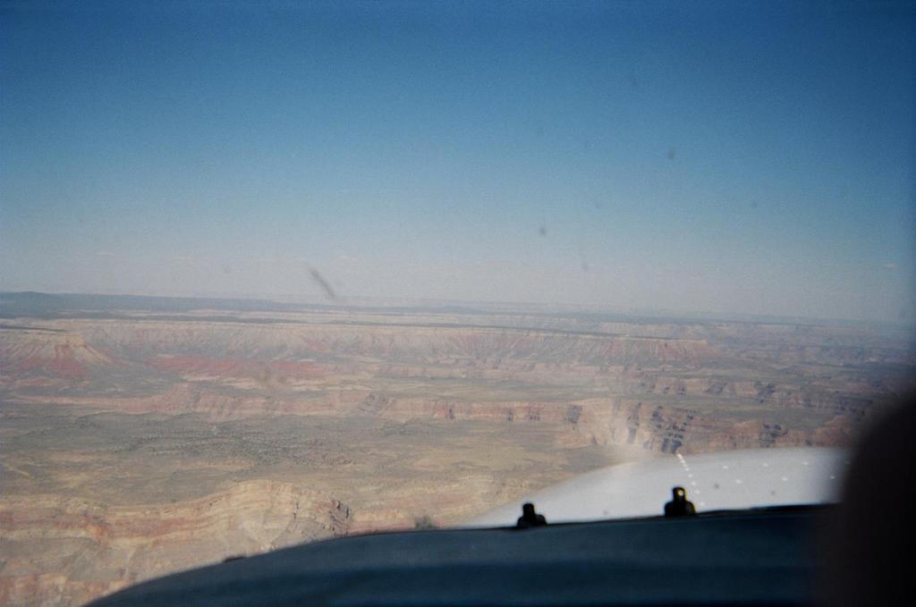
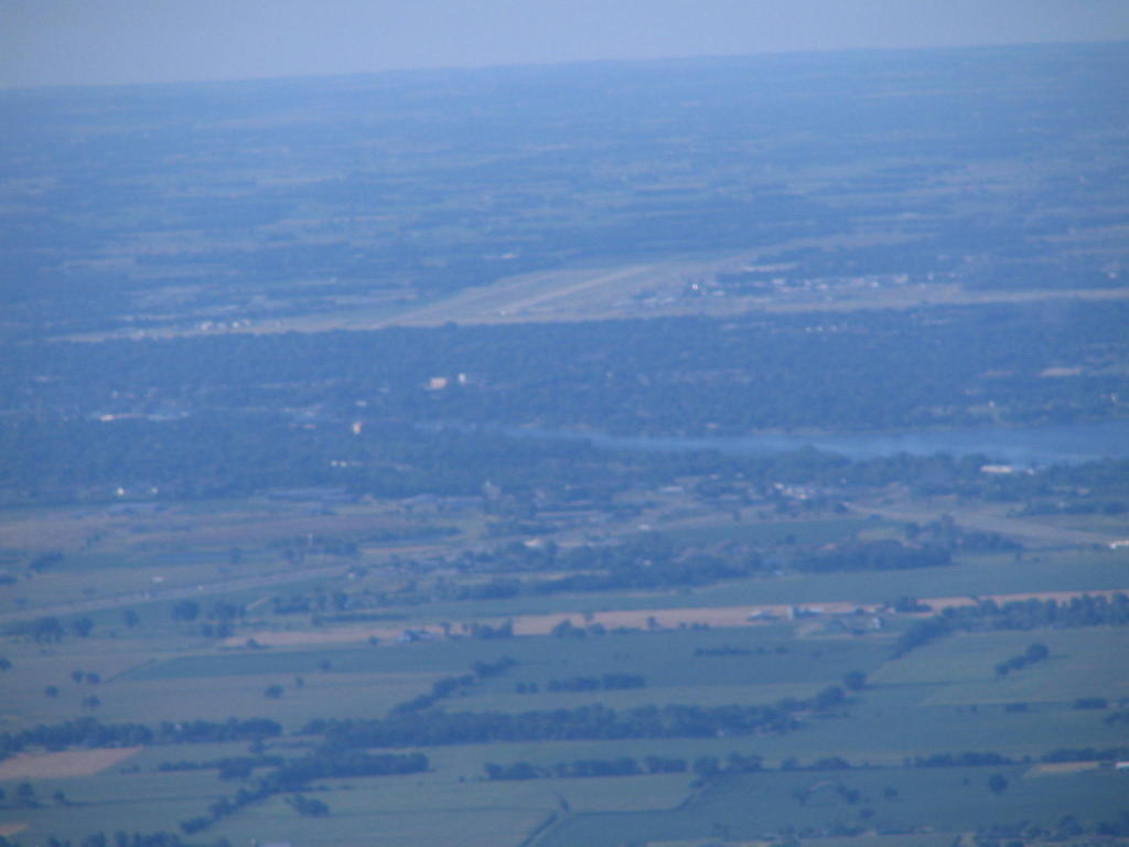
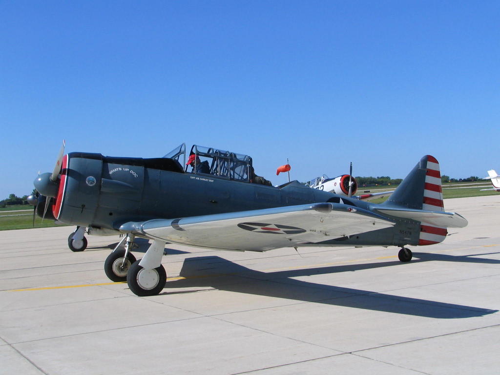
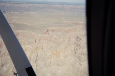
In a previous post, the IFR Pilot reflected on a past flight through the Grand Canyon while in Vegas on a business trip. Cleaning the deutritus from the computer, the photographic evidence of said trip was unearthed.

I arrived at North Las Vegas Airport to the offices of First Flight Aviation. I chose them based on favorable comments on AirNav.com. My appointment is with Will, one of First Flight's CFIs. He's your typical flight instructor: young, male, full of energy. I'll be flying N623SP, a Cessna 172SP. I logged a bunch of SP time getting my private before buying 78S, so this is familiar territory.

After a preflight, we taxi out and takeoff. Climb performance isn't too bad, considering the density altitude. It's easily got to be more than 100 degrees on the tarmac. We skirt the military airspace southeast of VGT and head for the Grand Canyon. The scenery is absolutely spectacular!


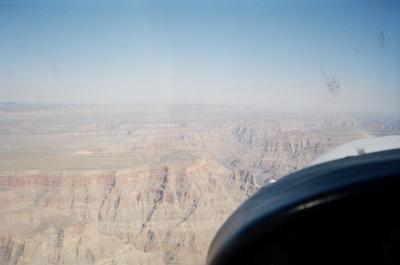
We proceed east, and make our way to Grand Canyon West Airport. Will tells me that the airport abuts the Snake River Canyon where Evel Knievil had the famous Skycycle jump back when the IFR Pilot was Wee Little Wanna Be Pilot. It's not obvious here, but these pictures, taken at the threshold of Runway 35 (I think), show the area in which Evel did his stunt. (Further research shows that this is total bull, as Knievil's jump was in Idaho. Oh well, whatever. It's still awesome to behold this natural beauty.)


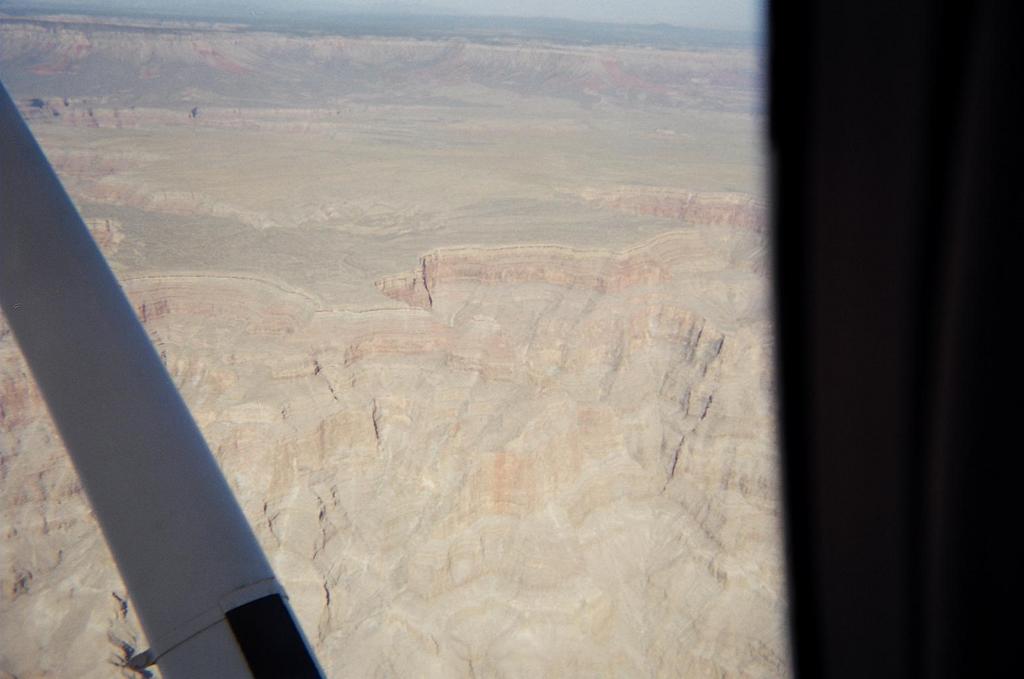
The takeoff plays a few ticks on the IFR Pilot's brain. One minute, we're just a couple hundred feet off the ground. Then, the ground drops away as we cross over the edge of the cliff. Suddently, we're a whole lot higer above ground. Weird.

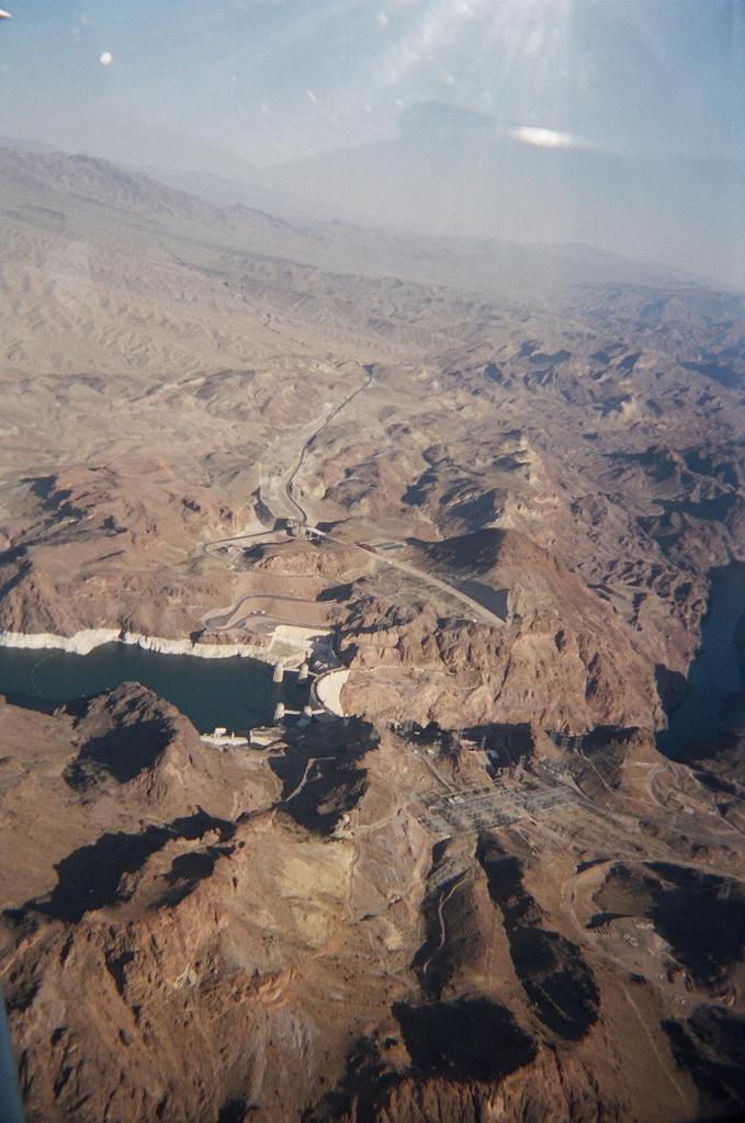
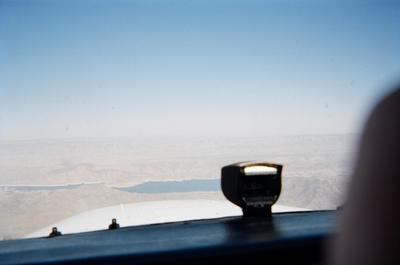
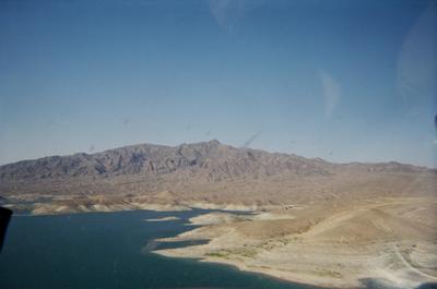
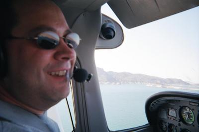
Anyway, next on the list of sights is Lake Mead. Will decides that the IFR Pilot needs a lesson in low-level flight, and says that we'll make our way down to about 50 feet of the lake floor. Um, ok, are you sure about this? I guess it's kosher. If memory serves, it's Class G airspace and there's not likely to be any structures around that we'll run into. Here's proof that we did the deed:
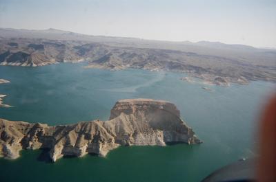
Going lower.

Really low now.

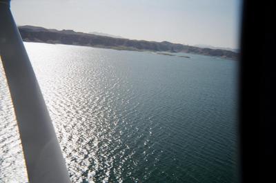
This is about 50 feet or so ALL (above lake level).


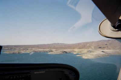
Proof that the IFR Pilot was actually flying this low (look out the window):


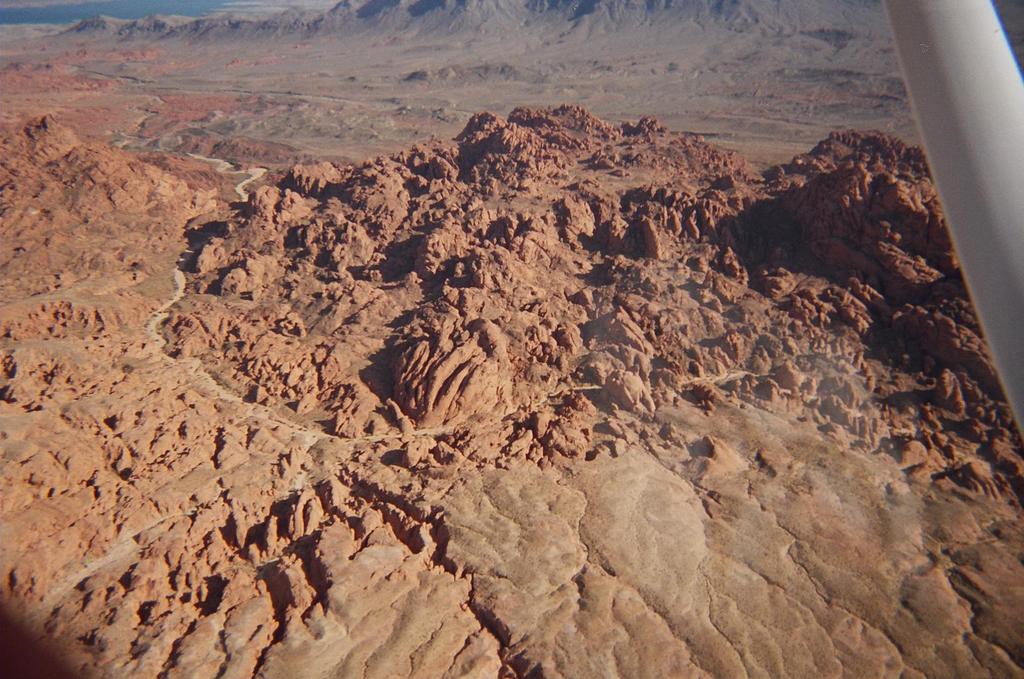
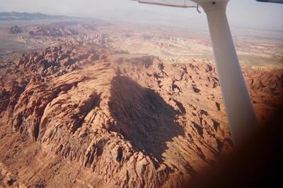
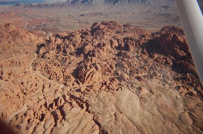
We leave Lake Mead and head for some intriguing rock formations that Will knows. I forget if they had a name. But, as you can see for yourself, they were awesome looking!


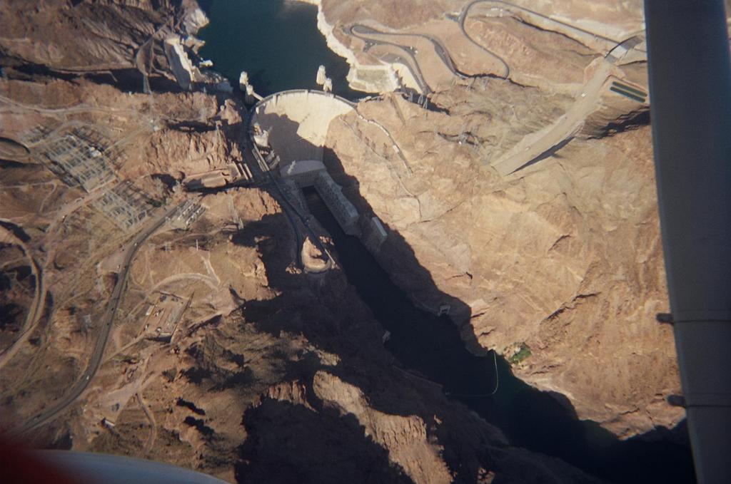
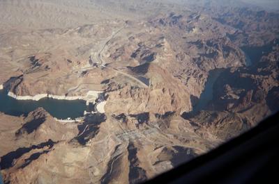
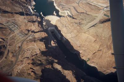
Next up is Hoover Dam. There's a discrete frequency for flying over the Dam. Yes, yes, you report "Dam Traffic." Yuck, yuck, yuck. What's perhaps a bit more interesting to note is that even in this ear of post-9/11 security paranoia restrictions vis-a-vis general aviation, we're still able to circle the Dam and get a bird's eye view of this man-made Wonder of the World.


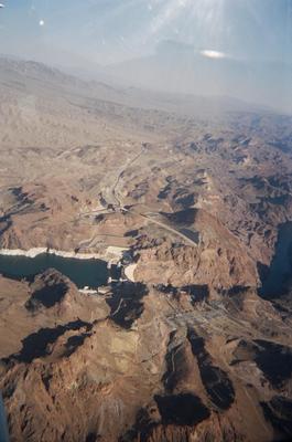
After touring the Dam, we head back for Vegas. We get a vector that clips Henderson's airspace and then, of all things, a vector right over the top of McCarran International. As you can plainly see, the Strip isn't very far from the Airport.


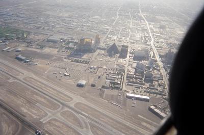
After that, it's a quick hop up to VGT and we put 3SP back to bed. All in all, a great way to end a trip to the Aviation Insurance Association annual convention.

Take the IFR Pilot's advice: Next time your in Vegas, rent a plane and do some aerial sightseeing. You will not be disappointed, and the memories will last a lot longer than the 20 minutes at the Texas Hold 'Em table, where you lost enough to pay for the entire flight!!!

Friday, August 19, 2005

Accident of the Week

One of the things that the IFR Pilot does to learn is read NTSB accident reports. The thought is that perhaps reading about the choices the led some pilots to commit fatal or near-fatal accidents might sharpen my own decision-making skills. Here's this week's offering from the NTSB archies:

NTSB Identification: NYC05LA134
14 CFR Part 91: General Aviation
Accident occurred Saturday, August 13, 2005 in Erie, PA
Aircraft: Piper PA-28-180, registration: N7534W
Injuries: 3 Fatal, 1 Serious.
This is preliminary information, subject to change, and may contain errors. Any errors in this report will be corrected when the final report has been completed.

On August 13, 2005, at 2114 eastern daylight time, a Piper PA-28-180, N7534W, was substantially damaged during a forced landing, following a total loss of engine power on approach to Erie International Airport (ERI), Erie, Pennsylvania. The certificated private pilot and two passengers were fatally injured, while one passenger was seriously injured. Night visual meteorological conditions prevailed for the flight that departed Jamestown Airport (JHW), Jamestown, New York. No flight plan was filed for the personal flight conducted under 14 CFR Part 91.

According to a Federal Aviation Administration (FAA) inspector, the flight originated from Smyrna, Delaware. The pilot flew to Randolph, New York, dropped off two of the passengers, and continued to Niagara, New York. He did not purchase fuel in Niagara, and fuel services were not available in Randolph. The pilot later returned to Randolph and picked up the two passengers. The pilot and three passengers then departed for Jamestown to purchase fuel; however, when they arrived, the fixed based operator was closed for the evening. The pilot did not utilize the after hours telephone number for fuel services at Jamestown, and elected to depart for Erie to refuel.

About 12 miles east of Erie, the pilot reported fuel exhaustion to air traffic control. He attempted to glide the airplane to runway 24, but it impacted a wooded area about 1 mile east of the runway.

Examination of the wreckage by an FAA inspector revealed that the left wing was compromised. The right wing remained intact, and contained about 16 ounces of fuel, with some water observed in the fuel sample.

Reading this accident really left me scratching my head, as it's one of those that seems totally preventable. Here's the route of flight (assuming all legs were flown direct):


The Airplane Flight Manual (AFM) for the PA-28-180 indicates a total fuel capacity of 50 gallons, of which 2 are unusable. The manual further states that the fuel consumption, when operating at 75 percent power, is approximately 8.8 gallons per hour in cruise flight, assuming the engine is leaned according to the manufacturer's specifications. We don't know how aggressive the accident pilot was in leaning the airplane. From my own experience, it's a lot easier to lean with the benefit of a multi-probe graphical engine analyzer. Sure beats "lean until it runs rough, then turn the mixture clockwise a bit to enrichen it," which is how I learned in the ol' 152.

Why didn't the accident pilot get fuel in Niagara? He had already landed at Randolph, so presumably knew that when he went back to pick up his passengers, he wouldn't be able to get fuel there. I've never been to Randolph, but it strikes me as the protypical country airport. Single turf runway, about 2500' in length. Couple of airplanes based there.

Admittedly, fuel at Niagara is expensive. At last report, it was $4.02. But it's not much cheaper at Jamestown, where he did try and get fuel. Per AirNav, $3.90 per gallon at JHW.

So, you land at JHW, knowing that you need fuel. You decide not to pay for a call-out. OK, I probably wouldn't want to pay $25 or so for an after-hours call out either.

But, why try to go all the way to ERI? Why not go to Dunkirk, due north of your position about 11 minutes away in a 172? Probably because it takes you away from your final destination of Erie. Yet, it seems much more prudent to make an 11 minute flight there than to try to make it a half-hour or so to Erie.

My point here isn't to castigate the accident pilot. Nor am I trying to express any value judgments. Perhaps the NTSB investigation will show that they needed to be in Erie at a time certain. I don't know.

I do know that reading about these scenarios is helpful for that little voice in my head that talks to me when I'm flying. "Are you sure that you want the NTSB to find out that you did xxxxxx?" -- whatever xxxxxxx might be. "Consider your alternatives." "Are you sure about the choices that you are making?" And so on.

The moral of this week's accident exemplifes the old aviation mantra, "You never have enough fuel except when you're on fire."

Thursday, August 18, 2005

Goodbye Friend. I Hardly Knew Ye.

*sniffle, sniffle*

Today, a dear friend and I must part company. Faithful companion. Reliable. Never complained. Always willing to go with me, even at the last second.

Weep not, dear readers, for parting is sweet sorrow. And good for my checkbook. Ka-bam!!!

Yes, yes, the Bose Headset is being sent back today. Along with the completely unused AeroShell Flight Jacket.

Why, you ask. You know why. Just look at the price of avgas. Jeepers, it's pushing $4.00 or more at most places. I'm making an Angel Flight next week to SYR, and they want $4.71 to refuel. Um, hi, I'm a mere mortal, could you please not rake me over the coals for doing something nice for people? Please, please.

Anyway, say goodbye to Mr. Bose's delightful design. Wish I could justify keeping it, but for the relatively limited number of hours that I fly most months, $1000 for a headset can't be justified economically. It'll have to wait until I chuck this day job and become a CFI or freight dog.

Or, maybe keep my day job and still be a CFI. Hmmm, maybe it's time for the IFR Pilot to consider becoming CommercialPilot. Whatchall think about dat?

Monday, August 15, 2005

Been There, Pick a New Destination!

Found on another aviation related blog that I read, also-known-as, was a link to this site, where you can generate a map of places that you've visited. So, I promptly opened the logbook, and generated this map of places where I've landed or taken off.


Mississippi isn't in red, since I flew over it on the way to New Orleans, but didn't stop there. Nevada is highlighted since I went flying there during a seminar for work. That flight around the Grand Canyon was awesome! I'll have to dig out the digital pics of that flight and put a post here, for posterity's sake.

By my count, I've covered half of the U.S. in the four years that I've been flying. Not bad. Guess I've got something else to shoot for during the next four years!

Tuesday, August 09, 2005

Alaska Epilogue

Having now been back for a comfortable period of time, a bit of reflection is in order.

There's no question that flying yourself to Alaska via light airplane is the adventure of a lifetime. This is particularly true if most of your flying has been in the Great Plains, such being the case with the IFR Pilot. A few flights over "mountains" in central PA and on the way to DC constituted the only rugged terrain that I had ever crossed in my trusty 172. Needless to say, the sights that you see between the Midwest and Alaska are truly awesome.

Flying the Alaska Highway proved to be a very safe choice, both up and back. Other than one leg where I flew direct so as to avoid weather that was building over the highway in the mountains, we basically had an emergency landing strip below us.

There was the occasional lake crossing, and mostly what I did was look for the shortest point to cut across or, if possibly, just skirt the edge.

You certainly learn a lot about flying in other than ideal conditions. I'm not talking about IFR flying here, that's just not really an option in a 172 in the moutainous terrain of nothern Alberta and the Yukon. I'm talking about cloud decks about 5000 MSL that require you to assess whether you can keep enough altitude between you and the terrain and still stay below the clouds. I'm talking about flying through rain showers where you can clearly see through them. I'm talking about learning to skirt an isolated thunderstorm, which at least in the Midwest is not always easy to do given the size of storms that we get here. I'm talking about making sure that you are constantly ready to divert to unfamiliar airports to wait out unexpected weather.

Highlights: Oshkosh. Sea plane ride. Mountain scenery.

Lowlights: Rough engine. Rough engine. Rough engine.

For those that care, here's a rough plot of the route that we flew. I say "rough" because you can't really plot the Alaska Highway on the AOPA Flight Planner. Nevertheless, this is certainly sufficient to give you an idea of the amount of ground that we covered during our 2.5 week escapade:


According to the Flight Planner, this totals over 6000 nautical miles. That's a loooooooooong way, kids.

Total flight time was 58.2 hours. Fuel burned was 630 gallons. That's 10.8 gallons per hour, pretty close to the 10 hours I generally use when flight planning. I think we would have kept pretty true to that had I leaned as aggressively after Lethbridge than I did before it. Engine roughness tends to make one a bit gun-shy. Also, the EGT and CHT readings were off a bit, so I didn't want to take too many chances.

A final thought, with apologies to Mastercard:

Charts for the Alaska trip: $360.

Fuel for the airplane: $2300.

Maintenance during and after the trip: $250.

Flying your Dad to Alaska to fulfill a life's dream: Priceless.

Thursday, August 04, 2005

Danger, Will Robinson...

Conned one of partners in 78S to safety pilot for me tonight. Just wanted to fly some approaches and keep the instrument skills sharp. Flew the VOR 23 at Akron-Canton, the VOR-A at Kent State, and the LOC 25 at Akron Fulton.

No major problems, except that the Foggles don't go so good with the IFR Pilot's glasses. Usually, I remedy this by putting in contacts before doing training, but I got kept late at work and didn't have time to stop at home before meeting at the airport. Oh well.

I was a bit annoyed with the controller who let me blow through the localizer on the LOC 25 approach. I saw it coming, but he was handling a couple of other folks so I just played it out to see what I might expect on a busy IFR day. We were well outside the IAF, and so I thought he might just vector me back. No, that would be too easy, wouldn't it Mr. Controller? So instead, you give the IFR Pilot a 320 degree left hand turn back to the localizer.

Now I know this is only a practice approach in VFR conditions, but if we were in actual, don't you think that a sustained turn like that might not be the best idea? Ever heard of coriolis illusion? Huh? Huh?

Oh well, all's well that ends well. Big thanks to my safety pilot who managed to get the runway lights turned on at the home base when the IFR Pilot couldn't make it happen. The mike sequence is non-standard and it just wasn't listening to me tonight.

Then, when I got home, I got an e-mail from the folks at AirJourney.com. Not sure how they got my e-mail, but that's OK. Looks that they have some exciting opportunities to fly to all sorts of exotic destinations. This is just what the IFR Pilot needs -- a new project, such as planning for a trip like this one that they offer. I've always been fascinated by Iceland. This one also looks awesome!

I'm afraid that this is very, very dangerous. The IFR Pilot would look awfully good standing next to 78S at other worldly destinations, wouldn't he? Let me know which trip you think we should pick! Dadster, don't worry, I'll get a headrest installed on your chair before we go. It's almost enough of a reason to keep that little ole headset that's ready to be returned!

Wednesday, August 03, 2005

GST Refund

One of the things that I learned during the Canada portion of the trip -- and that I didn't see on anyone else's Flying to Alaska websites -- is that, as a non-resident of Canada, you are eligible to apply for a refund of the Goods and Services Tax (GST). As I perceive it, GST is basically national sales tax. About 7% on what seems like just about everything.

Well, as you can imagine, we bought lots of fuel in Canada. GST applies.

We had about a week of overnight stays. GST applies.

Paid GST on a variety of other things.

Unfortunately, I didn't find the brouchure about applying for a refund until fairly late in the trip. As a result, I'm not sure that (a) I kept all of the receipts that might have included GST, and (b) that all of the receipts that I do have qualify. They want original "receipts," and the brochure says that "credit and debit slips are not accepted." In lots of instances, the only thing that I got was a debit slip. But many of those have the GST itemized on it and the vendor's GST account number, so I'm hoping that these will qualify.

All told, there was about $156 in GST receipts in my rebate application. At current exchange rates, that's about $128 in Yankee dollars. Hopefully, that'll help pay the Nav Canada bill when it arrives, assuming I actually get that much in the refund.

So, my advice to those of you flying North of the Border: Keep your receipts!

Tuesday, August 02, 2005

Day 19 Summary

OK, OK, y'all have been quite patient with the IFR Pilot and his heretofore lame excuses for not posting the final installment of the Great Alaska Flying and Ice Cream Adventure. Let's see if I can remember what happened on that fateful day last week....

Morning came early to Appleton, Wisconsin. The IFR Pilot and Dadster awoke promptly, checked out, and were at Outgamie Regional Airport by 7:30-ish. We paid our fuel tab and got an escort to the parking area. It was a gorgeous morning, weather wise, and the plan was to ride the tailwinds to Valparaiso, Indiana, refuel, and then get home. Whereupon the Dadster could recharge his batteries in anticipation of the long, long car ride back from to his home base.

Departing Appleton, we headed due south. That put us smack dab in the thick of Oshkosh traffic. I lit up all available lights and climbed to what I thought would be a healthy altitude to keep us clear of the traffic inbound to Oshkosh. The plan seemed to work, because although we heard a continuous stream of traffic both inbound to and outbound from Oshkosh on the radio, we only actually saw one plane in our vicinity.

There's not that much to see, but I snapped a quick pic as we passed west of OSH:


Well, as we approach Chicago's airspace, our travel plans were amended for two reasons. First, I could tell that the weather east of Chicago wasn't CAVU. Second, the IFR Pilot needed to tend to, um, "environmental needs." So, we dived bombed for a past destination: De Kalb Municipal Airport, where we had stopped for fuel on Day 1.

The line guy was helpful, but frankly, I think he's been pumping too much av gas. That he had several aircraft on the ramp at once seemed to perplex him beyond what it should have. And, after determining that some IFR flight was going to be required to get home, he was really confused when I asked to buy a Low En Route Chart. Of all things, they didn't have one. Dadgumit.

On the ground at De Kalb were a trio of gorgeous warbirds that, of all things, were not headed to Oshkosh. I think they were making their way home.


The weather between Chicago and home base wasn't pretty. I elected to make another intermediate stop, this time in Toledo. In an effort to try and stay out of Chicago's way, I filed DKB-JOT-TOL, thinking that route might cut the mustard. Of course not. The actual route, if I remember, was "radar vectors, direct Gipper, direct Toledo." Well, "radar vectors" was pretty much all the way to South Bend, home of the Gipper VOR (GIJ). Think "big huge arc south of Chicago and just over the edge of Lake Michigan, taking me well out of a simple, direct path to my destination." Even 10 miles south of GIJ, when I asked for direct Toledo, I couldn't get it. Egads, maybe I should have overflown the lake. On second thought, nah.

I filed for 9000 out of Chicago, hoping to climb over the cumulus that was building. Approach warned me, "I'll have 9000 as your final, but it won't be for a while." Three times I asked for higher, three times I got rejected. One call went like this:

"Chicago, 78S, any chance for higher at this time?"

"Nope."

That pretty much sums it up, huh?

Well, once under the control of South Bend we got our climb to 9000 and had clear sailing to Toledo. ATIS was reporting some clouds, but we were VFR all the way and got a visual approach.

After a quick lunch, I called Flight Service for a briefing back to the home base. It wasn't looking pretty. The system that had hammered the area the day before hadn't quite departed the area. The reports were of overcast at 500, but with decent visibilities. The briefer did say, "If you're gonna go, do it sooner rather than later."

That's all I need to know, let'd go Dadster.

The home base is VFR only, so I filed IFR direct to the airport two miles east. Once again, no go. Instead, I got send to a couple of VORs before direct to the IAF for the GPS 2 into 3G3. I filed for 7000, which was intended to keep me on top of it all.

Things were hopping at TOL, which I guess was understandable under the circumstances. After takeoff, I was promptly cleared direct to the first VOR and definitively instructed to expedite my climb to 7000. No problem and I "accomodated" the "request."

Handed off the Mansfield, things were looking just ducky. I had reviewed the approach plate a bunch of times, and had the approaches for the alternate -- KCLE -- readily available.

Fifty files from the IAF, Mansfield sent me down to 5000. Oy vey, that's right into the clag. To be honest, the IFR Pilot's not a fan of sustained single pilot IFR flight in an airplane without an autopilot. Indeed, if we're being honest, the IFR Pilot hasn't actually flown much single pilot IFR other than climbing or descending through layers. Well, in for a dime, in for a dollar, if it's that bad, we can always go back to Toledo for a visual. There's lots of fuel on board.

Jumping ahead, after 45 minutes, we were cleared for the approach. Unlike most standard GPS approaches that follow the "T" configuration, the GPS 2 into 3G3 involes flying from the IAF to the FAF via a heading of 003, then turning to a heading of 015 for the final segment. That's actually OK by me, because it elminates making a 90 degree turn in the scud.

Around 3000 MSL, we started catching glimpses of the ground at 3G3. I breathed a small sigh of relief, because to me that was an indication that the approach wouldn't be to minimums. Couldn't be sure, because there's no weather reporting at 3G3.

We broke out for good at 2300 with the runway right in front of us where it was supposed to be. Yeeeehhhhaaaaaawwwwwwwww, I did it!

After touching down and making a quick phone call to the home base, I learned that a couple other folks had just flown in there VFR. So I fired 78S back up and we flew the 3 minute trip to the home base. Over the top for left downwind, followed by a quick base and final and we were on the ground.

And so came to an end our great adventure.

Where to next???

Monday, August 01, 2005

Delays

Sorry about the lack of posts, folks. The IFR Pilot's been digging out from underneath the pile of papers on his desk at work and his pile of mail at home. Should have some time this week to do the Day 19 final report and a trip summary.

I did install the vertical card compass over the weekend. That's no small project. There isn't a lot of room underneath the glare shield of a C172. Took four hands, and we could have used one more! But, after it was all said and done, the vertical compass is surely a nice additional to the airplane. Hopefully, I swung it correctly. We'll see....