Thursday, June 30, 2005

It's Gonna Be A Long Flight....


Your thoughts on our routing are most welcome. I'm shooting for a couple of legs each day, each leg no more than roughly 3 hours. That's six hours of flying per day, with time in the afternoon for lunch and sightseeing.

We're planning to camp as much as possible, realizing that this will be more likely once we leave the continental U.S. Free shelter from sympathetic pilots is also most welcome!

Wednesday, June 29, 2005

Getting Worse


Looks like we might actually have been able to make the flight this morning, IF we had departed on time and not stayed at Rick's. More importantly, IF we had a Stormscope or Strikefinder on board. Perhaps it's time for another upgrade to the panel? Methinks so...

Vindication?

Below is the current radar image for the proposed route of flight. Not quite as much yellow and red as I thought, but note the red cell right on top of Indy. This is just about the time we would have been arriving there. Rick's will just have to wait!


Apologies to all for the crummy Photoshop annotations...

Scrubbed

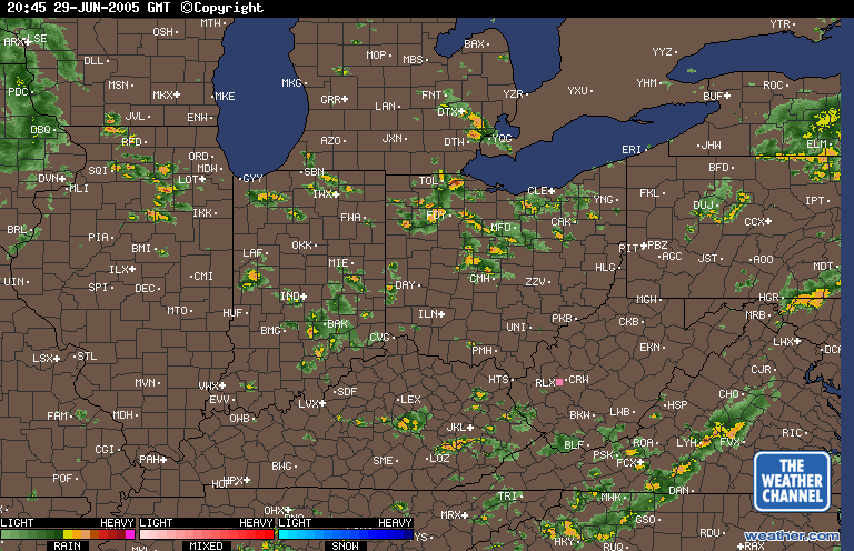
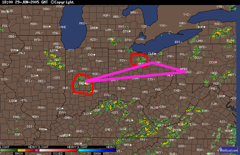
Today was supposed to be an Angel Flight from AGC to EYE. But yesterday, we got hammered by strong TS. Turns out it was about a 20 mile wide band that moved from SW to NE. Some of my pals saw nothing; the soccer match I was officiating had to be delayed 45 minutes due to lightning, and then moved to an adjacent field that wasn't underwater.

So I was very concerned about making a trip this afternoon. It's been plenty hot here of late, providing much fuel for the boomer clouds. I didn't want to abandon the passenger, but neither did I want to do damage to myself or my plane.

The FAs for the areas of flight were't too enlightening:
PA
ERN 2/3...BKN050 OVC100 TOP FL250. VIS 3-5SM BR. WDLY SCT SHRA.
15Z SCT-BKN060 BKN120. ISOL -SHRA. BY 19Z WDLY SCT TSRA. CB
TOP FL350. OTLK...VFR SHRA.
WRN 1/3...BKN-OVC040 TOP 080. VIS 3-5SM BR. 15Z BKN060 TOP 100.
OCNL -RA. 18Z ST-BKN060. WDLY SCT TSRA. CB TOP FL380.
OTLK...VFR.
OH LE
LE/ERN HLF OH...BKN020 TOP 040 BKN CI. VIS 3-5SM BR. ISOL EMBD -
TSRA. CB TOP FL300. 14Z SCT060 BKN CI. BY 18Z WDLY SCT TSRA.
CB TOP FL400. OTLK...VFR.
WRN HALF OH...SCT050 SCT-BKN120 TOP FL200. VIS 3-5SM BR. ISOL -
TSRA. CB TOP FL300. 17Z SCT-BKN060 BKN120. WDLY SCT TSRA. CB
TOP FL400. OTLK...VFR TSRA. 00Z VFR.
IN
NRN...BKN100. ISOL -SHRA. OCNL VIS 4-6SM BR HZ TIL 15Z. 18-21Z
AGL SCT050 BKN-SCT120. OTLK...VFR.
SRN...SKC. OCNL VIS 3-5SM BR HZ TIL 15Z. 17-19Z AGL SCT050. AFT
20Z ISOL -TSRA. OTLK...VFR.

A couple of the TAFs had me worried, though, especially about the trip back:
TAF KCMH 291123Z 291212 VRB02KT 4SM BR BKN150
FM1300 VRB04KT P6SM SCT040CB TEMPO 1720 3SM -TSRA BKN035CB
FM2000 22004KT P6SM SCT050
FM2300 VRB02KT P6SM SCT250
FM0500 00000KT 4SM BR SCT250

TAF KLCK 291123Z 291212 VRB02KT 3SM BR BKN150
FM1300 VRB04KT P6SM SCT040CB
TEMPO 1720 3SM -TSRA BKN035CB
FM2000 18004KT P6SM SCT050
FM2300 VRB02KT P6SM SCT250
FM0200 00000KT 4SM BR SCT250
TEMPO 0912 1SM BR

TAF AMD KFFO 291409 21004KT 9000 BR FEW050 FEW120 BKN250 QNH3001INS
BECMG 1416 25015G25KT 4800 -TSRA SCT020 BKN030CB QNH3003INS
BECMG 2021 21004KT 9999 FEW030 SCT100 QNH2995INS WND VRB04KT AFT
01 T30/20Z T21/08Z AMD 1405

TAF KDAY 291123Z 291212 VRB04KT P6SM SCT040CB TEMPO 1618 3SM -TSRA
BKN035CB
FM2000 18005KT P6SM SCT050
FM2300 17003KT P6SM SCT250
FM0800 18004KT 5SM BR SCT250
All in all, to me, this added up to a pretty good chance that we'd be in the clouds, sans Stormscope. That's an easy no-go decision.

Talked to the linking pilot, with whom I'd shared my concerns the night before. Turns out, he was able to put the passenger on a Southwest flight direct to IND for less than he'd have spent on avgas for his trusty steed. A bit of an inconvenience for the passenger, but at least she'll get home, and I get to remain in one piece.

We'll see what actually develops on the radar later today. Meantime, it's back to my day job.

Monday, June 27, 2005

Charts Redux

Upon returning to the office today, a package was waiting for me -- a bunch of charts gathered by the friendly folks at FlyNorth.com. The package consisted of the following:

U.S. VFR Sectionals for Anchorage, Dawson and Fairbanks. (Seward to arrive later).

U.S. Terminal Area Chart for Fairbanks.

U.S. Alaska Flight Supplement.

Canadian Sectionals for Atlin, Calgary, Edmonton, Fort Nelson, Fort Simpson, Kitimat, Klondike, Prince George, Vancouver, and Whitehorse.

It was quite a pile of stuff, as you can see for yourself:


About the only significant chart that wasn't included is the Alaska Highway sectional. Plus the other sectionals that I'll need to get from here to Lethbridge, where we'll make the border crossing.

When you combine it with the WACs and other materials that I've been assembling, you can clearly see that we're talking about a lot of paper to drag along:


Fortunately, I've found a nice little box into which everything fits pretty neatly.


I think I may omit all of the state charts in favor of the sectionals. But, I can't decide whether to drag along all of the state airport directories, or just rely on the AOPA Directory. I'll probably drop them also, in favor of the "official" Airport Facility Directories.

One of the most useful charts that FlyNorth.com included was the British Columbia Aviation Council Air Facilities Map, onto which Diana at FlyNorth has marked out the three most popular routes to/from Alaska: The Alaska Highway, The Trench, and The Stewart/Cassair Highway. Click below for a large-size, super-fine photo of same:

I guess it's about time to actually start doing some flight planning. We're departing in less than 2 weeks!!!

Tuesday, June 21, 2005

"33"

Before departing for the soccer tourney today, one of my co-owners and I made a quick hop over to Latrobe, PA, home of world-famous Rolling Rock beer. No particular reason, just an excuse to go fly someplace and be back in time to make the commercial flight out of Hopkins.

The weather was borderline crummy. There was basically no horizon due to widespread haze. We could see the ground below us from 5000 MSL, but visibility couldn't have been more than 3 or 4 miles at best. See for yourself:


I filed IFR direct and handled the outbound leg. We spent a little bit of time in the clouds, and I shot the ILS 23 into KLBE. Had the airport from 5 miles, transitioned to the visual and made a nice landing.

John handled the flight home. This was his first flight in actual, so I backed him up on the controls, but basically let him do the piloting, while I handled the radios so he could remain focused on scanning. I probably did too much talking, but what the heck, I like the sound of my voice anyway.

Obligatory picture of John doing the IMC thing:

Our route took us right over the top of Pittsburgh International, which made for this lovely shot:


We also got routed over the top of CAK, and saw a behemoth of an aircraft parked on the runway 32. Not sure what it is, but it was HUGE. Witnesseth:


Wednesday, I'm scheduled to make an Angel Flight. The forecast is calling for showers and isolated TS. John's going to co-pilot for me, so this was a good dry run for us. We'll be flying the patient from AGC to EYE. And, of course, treating ourselves to a fine meal at Rick's Cafe Boatyard, a can't miss when you popping in to Eagle Creek.

And the reason for the title of this post? Go here. Or here.

Monday, June 20, 2005

Time to write something

Haven't had much to say the last week, sorry fans. Got an e-mail that the Canadian and Alaskan maps package is on the way. Once that arrives, I'll just need a couple of sectionals, and that should do it. Throw it all in a box, see how much it weighs, then try to figure out how many less pairs of socks I can bring with me and still remain under max gross weight.

Anyone know if it's legal to remove the rear seat from a 172 and fly without it? I mentioned this to my A&P recently, and he didn't think it was kosher to do so. Something about not complying with the type certificate. Perhaps a call to the local FSDO might find the answer. Like many pilots, however, I disdain voluntary contact with the FAA.

My skepticism is heightened by the number of pilots I counsel via the AOPA Legal Services Plan. Can't share too many specific details, lest I violate attorney-client privilege. I can say that some of the investigations and enforcement actions are well-grounded and justified. A substantial number of them, however, are pure bunk and smack of bureaucrats running up their statistics to justify their agency's budgetary request from Congress next year. *Rant mode off*

Starting to pay a bit more attention to the large-scale weather systems that are developing. Last year's trip with Dad was substantially impacted by weather, primarily a tropical storm that moved up the Atlantic seaboard and ruined all of our carefully laid plans. You can read about it here.

Tomorrow, our hero departs to pursue his other hobby -- soccer refereeing -- for a week at this tournament. So don't expect much to be posted in the interim.

Tuesday, June 14, 2005

Crash update, Part Deux

Here's the initial workup on the crash at our home airport from the NTSB site:

NTSB Identification: NYC05LA092
14 CFR Part 91: General Aviation
Accident occurred Tuesday, June 07, 2005 in Wadsworth, OH
Aircraft: Piper PA-44-180, registration: N2148F
Injuries: 2 Uninjured.

This is preliminary information, subject to change, and may contain errors. Any errors in this report will be corrected when the final report has been completed.


On June 7, 2005, about 1230 eastern daylight time, a Piper PA-44-180, N2148F, was substantially damaged during an aborted takeoff from the Weltzien Skypark Airport (15G), Wadsworth, Ohio. The certificated flight instructor and a student pilot were not injured. Visual meteorological conditions prevailed and no flight plan was filed for the local instructional flight that was conducted under 14 CFR Part 91.

According to written statements, the pilots were attempting a short-field takeoff from runway 21, a 2,360-foot-long, 37-foot-wide, asphalt runway. As the student pilot began the takeoff roll, the flight instructor reduced the right engine throttle to simulate an engine failure. The student pilot reduced the left engine throttle, and began braking. The flight instructor then instructed the student pilot to resume the takeoff, and the student pilot advanced both throttles forward.

The flight instructor reported that the student pilot attempted to rotated the airplane at an airspeed of 63 knots; however, the airplane did not climb. The flight instructor then reduced the throttles and began braking. The airplane departed the end of the runway, rolled though a ditch, and came to rest in a field.

Initial examination of the airplane by a Federal Aviation Administration inspector did not reveal any mechanical malfunctions.

The flight instructor reported that at the time of the accident, the winds were calm, and the outside air temperature was 92 degrees Fahrenheit. The airport elevation was 1,210 feet.


I'm not multi-engine rated or a CFI, but I have to wonder about the wisdom of attempting a single-engine climb from our relatively short runway under high density altitute conditions. You'd be better off trying it at Wadsworth Muni or Medina, where the runways are a bit longer and thus there's a higher margin of error.

Plus, it doesn't sound like there was a complete understanding between the CFI and the student pilot as to what was occurring. In addition, the report doesn't indicate it, but I wonder if this was the first or a subsequent takeoff.

A reminder that danger is always lurking in aviation, and you've got to remain focused at all times inside the cockpit. I'm just glad that no one was injured in the accident.

Reviewing the NTSB website indicates that June hasn't been a good month for multi-engine pilots in our area. See for yourself...

Monday, June 13, 2005

Hello? Hello?


Our hero, 50' off the surface of Lake Mead. April, 2004.

I believe that we've now established that it will be possible to post some photos of the trip to Alaska while en route. Assuming, of course, that our hero is able to conquer the technical challenge of connecting to the Internet while in remote locations of the U.S. and Canada. We shall see....

Saturday, June 11, 2005

Breakfast Run

Today's mission was a little breakfast at one of the local airplane restaurants. A short little jaunt from the home base to a nearby Class D airport. (Sidenote: The Base Closing Commission included the Air National Guard squadron at this airport on its hit list. Could this be the prelude to closing the tower, then decommissioning the ILS? Inquiring minds want to know.)

The weather here has been awful lately. 90+ degrees, with dewpoints above 70. For those of you that can't figure that out, picture tropical rain forest, only without the lush tress and vegetation. Hot, sticky, yucky. Visibility was still good, at 7 miles, and the clouds were scattered to broken at 7000 or better.

I filed an IFR flight plan anyway, just in case the weather went to pot on the way over. It's only about a half hour flight, but my experience is that the weather can be much worse at this airport when it's still pretty benign at the home base.

Anyway, flew the ILS 32, although I had the airport from the second that they turned me on to the FAF. The landing wasn't too bad, either. I was carrying 3 pax, so the CG was noticably different. Still well within the W&B envelope, mind you.

After scarfing on the #1 special, we headed back. Tower asked me for an immediate left turn over the top of the airport to clear traffic that was inbound on the ILS on the other runway. Happy to oblige.

I switch to departure to get flight following. The visibility has reduced somewhat, but it's still VFR legal. That is, right until I flew smack dab into the cloud.

I swear, I didn't even see it coming. One minute everthing was fine, the next minute -- POOF -- where'd the horizon go? I quickly turned out of the cloud, then called departure and got a pop-up clearance to the neighboring airport that has an approach. (Our home base is VFR only.)

Pretty uneventful after that. Flew on the gauges for a couple of minutes, then emerged into VFR weather for the rest of the flight. A nice near-greaser of a landing, then tuck the plane away for the day.

All in all, it was a good experience. Just because you've only been on the ground for a little bit, you might want to go ahead and get that weather briefing -- even if it's only an abbreviated briefing. Also, it was much easier to get a pop-up IFR clearance when I was already on VFR traffic advisories. I think it's fair to say that I now have a new-found respect for the lurking danger of inadvertent VFR into IMC. Which is a great reason to keep one's instrument ticket current.

Thursday, June 09, 2005

Timing is everthing

Went to order the remaining charts that I need for the trip. Found out that the planned date of departure, July 9, is two days after the change of cycle for low alititude en route charts and Terminal Procedure Publications. It's also the change-over date for a couple of sectionals that I need. RATS!

This means that instead of ordering them from a discount supplier, I'll probably end up having to buy this stuff at the local pilot shop. I don't mind patronizing them, but with the sheer quantity of things that I have to buy for this trip, I was hoping to save a few pennies buying charts over the 'Net.

Oh well, I'll order the remaining sectionals, save a bit there, and plan to spend another night camping instead of in a hotel during the trip!

Wednesday, June 08, 2005

Crash update

Confirmed that noone was hurt in yesterday's incident with the twin. Turns out that I know one of the occupants.

Here's a picture of how the plane ended up:

Tuesday, June 07, 2005

Fully current!

A pleasant after-work diversion this evening was 1.3 hours of flight time, including .8 at night and .6 under the hood. Flew an ILS into a local regional airport, followed by an ASR approach. This is only the second time that I've flown a radar-based approach, and the first time at night.

I usually don't ask for them, they are extra work for the controllers. But someone else did, and when they got the OK for it, I asked for one too. Sometimes you get what you want.

It was fine. I got established on the inbound course, and dove to the MDA. Once I leveled off there, I was able to fly the approach course without too many correction instructions from the final approach controller. Got to two miles before the runway (which was 1.5 miles from the MAP), lifted the foggles, and transitioned to a visual approach for a stop and go. Then it was back home VFR. With three night landings, I'm night current for the Alaska trip. And with the two instrument approaches, I'm IFR current until late August. (If I fly a hold, then I'll be IFR current until the end of September).

Our home base had an accident today. The twin apparently wasn't climbing out very well, and struck the "barber poles" that are located across the street from the approach end of the opposite runway. Thankfully, as I understand it, the occupants of the plane are OK. The plane, on the other hand, won't be. This, just a month after the only complex trainer at the field struck a deer on takeoff at an airport in Tennessee, substantially damaging it.

At least there's fuel in the tank...

Monday, June 06, 2005

Two Hundred Pounds Lighter

Sorting through the hard drive uncovered this e-mail I wrote to my Dad about my first solo. This is as good a place as any to reprint it for the sake of posterity. Enjoy!

Early on the morning of November 7, 2001, I achieved a dream that I had had since I was a small child. I flew an airplane. Alone. By myself. With no one else in the cockpit. Yes, I soloed. An incredible milestone in the pursuit of a private pilot's license.

I had thought that perhaps I was getting close. On Monday's lesson, I achieved some sense of accomplishment with getting the landings right. I did six in a row with no major gaffes. Tires were still intact, no one chipped any teeth, and the person who was next scheduled to fly the plane could - without a visit to the maintenance shop. Hey, progress. My confidence level was boosted when my CFI, Mike, remarked "One or two more days like that, proving that today was no fluke, and I'll let you
solo."

So, when Wednesday morning rolled around, I wasn't 100% sure that today would be the day. I thought it was more likely that he'd sign me off on Saturday, if Wednesday went well.

After an uneventful takeoff, we started with a normal landing on runway 24R. I really like that runway, its 6100' long and 150' wide. That extra width allows a little bit more focus on the flare and landing without having to worry about being exactly on the centerline. I know it's important to stay there, but I can polish the details later, after I master the specifics.

Second time around the pattern, as we approach the reportig point, Mike says, "Ask for the option this time." Uh oh, that means he's up to something.

"Cessna 589 is midfield downwind, requesting the option."

"Cessna 589, runway 24 right, clear for the option."

"24 right for the option, Cessna 589."

As we get appraoch abeam the numbers, Mike pulls the throttle to idle. "Engine out. Let's make an emergency landing." OK, only we've never had to do this before.


"Tell me what to do," I say.


"Turn base now, no flaps until short final."


So I do what I'm told, and somehow manage to get it right.

Third time around to 24R, Mike calls for a no flaps landing. Again, something we haven't done before. This is something of a challenge because you come in faster and steeper. (Flaps are used to change the wing camber and lower stalling speed. That means you can come in slower.) Once again, after getting the necessary instructions from Mike, I pulled this one off.


It also involved a slip to landing, otherwise known as a forward slip. It's a procedure for losing altitute quickly. You apply a slight bit of aileron into the wind, and lots of opposite rudder. All the way to the ground, in fact. It feels a little wierd, the opposite pressures of varying intensity. But you change from a descent rate of 300 to 400 feet a minute to as much as 1000 feet per minute. You don't need to do it for very long, 10 or 15 seconds, although it feels like an eternity.


Trip four was a go-around. No problem there, even though we hadn't done one in a while. Like everything else in aviation, there's a silly little saying to help you remember what to do. This one is "cram, climb, clean, call and confess." Basically, when you decide that the landing is no-go, you apply maximum throttle (cram), turn the carb heat off and slowly retract flaps (clean), then make a radio call and announce you're going around (call and confess).


Trip five was another enginge failure landing. Again, I've got it.


Trip six, and ATC decides to throw one at us. "Cessna 589, make a short approach, clear runway 24 right."


I acknowledge, "Short approach. Clear to land 24 right. Cessna 589." Then ask, "Mike, what do we do now?" Yet another thing we haven't done yet. (Mike did one once early one, but we haven't covered it since then.)


Basically, a short approach implies just that. You want to set the airplane down as close to the runway threshold as you can, as slow as the plane will let you. It's a technique used on short runways and/or when there's traffic coming in on a direct final. So, instead of flying downwind until the runway numbers are 45 degrees behind you and then turning base, you chop the throttle when you are abeam the runway numbers, turn base immediately, and aim for the runway threshold. It's not unlike the no-engine landing. After it's all said and done, not that big of a deal and I nail it.


"Controller decided to jump on the bandwagon today and threw one at us as well," Mike remarks.


Felling a little cocky, I simle and say, "You guys are going to have to try a little harder to get me today."


"OK," Mike says. "You in a hurry to get back to work?"


"Not really. It's a little quiet this week."


"Feel like soloing today?"


Gulp. Wasn't expecting that. "Uh, sure. Why not?"


"Then make this landing a full stop."


ATC clears us to 24L this time, and we make a fairly normal landing. Not as nice as some of the earlier ones, but still fairly respectable. As we leave the airplane, Mike says, "I'm going to leave my headset here as a reminder of my presence."


We go inside the office, and Mike endorses my student license and logbook for solo flight. The restrictions aren't too bad: headwinds <>

Mike's last words to me were: "Don't worry, you'll be fine. I'll be right here watching. And remember, the plane's performance will be a little better without me. After all, you're two hundred pounds lighter. Give me three touch n' goes and we'll call it a day. If at any point you feel uncomfortable, c'mon back."


I go back outside to preflight the airplane. As I'm walking, I'm surprised that I'm not nervous. Rather, it's a strange, eerie calm. As I'm following my normal routine, I see something moving out of the corner of my eye. I lookup and it's the Fire Rescue Squad with their big rescue truck on the tarmac. Great, I think. This is a real confidence builder.


Preflight complete, I call for clearance from the tower. I wonder if I should add, "Caution, student pilot on first solo." Nah, I figure, why attract any additional attention.


After preflight, I get the weather information. Hasn't changed since earlier in the morning. That's good, I know where the wind is coming from and can deal with it. I taxi out to the run-up area and complete the run-up. Nothing else left to do, I make the call.


"Tower, Cessna 94589, ready for takeoff."


"Cessna 589, clear for takeoff, runway 24 left, make right traffic."


"Runway 24 left, Cessna 589."


I move out onto the runway, align with the center, and smoothly apply power. At 55 knots, I apply back elevator and -- whoosh -- up into the sky I go. It's amazing, the plane really does perform better without the second body in there. I climb to 1200 and turn right. Then it's up to 1500, turn left, lower the nose, and gain airspeed to Va (manuevering speed), 104 knots.


"Cessna 589 is midfield downwind."


"Cessna 589, clear to land, runway 24 right."


"Clear to land 24 right, Cessna 589."


Abeam the numbers, I apply the first notch of flaps. When we get to 45 degrees from the numbers, I lower power, drop the nose, add a second notch of flaps, and turn base.


Soon, it's time to turn final. OK, I've got my aiming point in sight. Remember, pitch for airspeed, power for altitude. Add a little power on short final when the plane wants to start sinking. OK, OK, getting close, start to flare. Hold the nose up, bleed of the speed. Hold it, hold it, hol...thump. A nice quiet two-wheel landing. I keep the nose off to slow down some more, then the nose gear falls.

ahort field landing implies just that. Ah, sweet success, a near-pefect landing.

Up flaps, carb heat off, full throttle, let's do it again!


Second trip around was uneventful, a mirror image of the trip before. Calm, quiet, and peaceful in the sky. A nice landing, another good takeoff. One more like that and we'll call it a day.


Only the controller has other ideas.


"Cessna 589 is midfield downwind."


"Cessna 589, make a short approach to runway 24 left."


Oh great. With only one such landing under my belt, he decides to make me do another. And then I hear him clear a jet for a 5-mile final approach to 24 right. Now I know why he wants me out of the way. And I want to cross over 24 right as soon as possible to get out of the way.


So I turn base right away. Frankly, I'm feeling a little overwhelmed this time. I had wanted just three, plain vanilla landings, and he throws in a little chocolate. Thanks alot, Mr. Controller.


I'm high, I can tell. I chop the power more, drop flaps. Still high, drifting left. Apply more right rudder, get back over the center line. The aiming points jumping up and down, which means I'm not holding a constant descent angle. Stabilize, stabilize, stabilize. The key to a landing, at least according to all the books and magazine articles I have read, is a stabilized final approach. And this one isn't.


Eventually, I manage to put the plane on the ground. It wasn't very smooth or pretty, but I still managed not to mangle the plane.


After I taxi to the ramp and park it, Mike's there, with a big smile and handshake.


And that's the story of my first solo, November 7, 2001.

Sunday, June 05, 2005

No Gas?

Back to the airport today, third day in a row! Went to fuel up, only to be told that the airport was OUT OF FUEL! It's self-serve, and we depend on the airport owner to keep us supplied (our airport is one of those rare-breed: privately-owned, public use). Rumor has it that he forgot to order more. I don't know for sure if that is true, but if it is, it's pretty amazing. Not only do you depend on fuel for pilots based there, but you need it for your rental fleet as well. And you forgot to order more????

Well, at least he owns the airport, so I guess he can't get fired, right?

My partner did all of the flying, I checked out the new GPS. It's indeed a beauty. I need to work with it some more, so I need to con one of my partners into going cross-country someplace, with me as co-pilot. That's the ticket!

Saturday, June 04, 2005

Keeping sharp

It's rather important to be pretty sharp on various flying skills for a trip of this length. As a result, now that we're about a month away from departure date, I've resolved to try and fly as much as possible. That was part of the reason for the planned trip to the AOPA Open House.

But when I called for an outlook briefing yesterday, the report called for ceilings of 500 to 800 feet around here, and weather not much better in FDK. Plus, a chance of TS in the afternoon. Easy decision: call the co-pilot and scrub that mission. My personal minimum: 1000 foot ceiling.

As luck would have it, the actual weather was nowhere near that bad, though I've consoled myself with the fact that I slept in and therefore the weather must have been much worse at the planned departure time. Did go up and practice a couple of ILS approaches. Since I didn't have another pilot with me, I couldn't do them under the hood or log them for the sake of currency per FAR 61.57(c). But, I got to practice the procedures, and that helps.

The worst part was as I was on the downwind leg for landing, and was established #2 behind another 172, some jerk crossed over the top of the airport and joined the landing pattern in front of me. And made no radio calls. Now, I suppose that he could have been NORDO, but nevertheless, I thought it particularly bad form for him to pull such a stunt. My home base is a fairly busy airport full of students and low-time pilots, so adherence to standardized procedures is important. The comdrade-in-arms apparently didn't think those procedures applicable to him. Next time, I'm launching the AMRAMMs loaded on my wing pylons...

Also went out on Friday night for the $100 hamburger chicken wings, and logged a night landing on the way home. There was a low overcast moving in, but we were able to stay below it with plenty of obstacle clearance. I want to do a few more night landings to keep my night currency under FAR 61.57(b)(1), just in case. From all that I've read, I think that we will have plenty of light even in the early evening. But, it pays to be current, so current I will get.

Friday, June 03, 2005

Route Planning

If it wasn't self-evident, this is the longest trip that I've ever planned. Picking the routing is no small task.

Originally, we were gonna join a guided flight with FlyNorth.com. We would have met up with them somewhere in Canada, and flown as a group up the Alaska Highway and back. Other commitments interfered, and so we had to push the trip back to a point where our schedule doesn't mesh with theirs. So, now we're gonna go it alone.

Part of the challenge, even if we had stayed with the kind folks at FlyNorth, was just getting from our part of the country to Canada. With a 172, range is an issue. Even with our extended range tanks, the amount of gear that we have to carry would and will limit the amount of fuel. I'm going to work up a speadsheet this weekend to consider various configurations to see what's going to work best.

In any event, there's lots of places to see between here and the Canadian border. So, rather than fly a great circle route to Dawson Creek (this one, not this one), where the Alaska Highway begins, I'm thinking we'll head straight west and try to see some sights. In particular, I'm thinking we'll aim for South Dakota and try to see Mt. Rushmore and the Crazy Horse Memorial. Then, we can turn more northwesterly for Canada.

I'd also like to see if we could include Cedar Rapids in our itinerary. Why you ask? Well, here's why. If you follow any of the rec.aviation newsgroups, you'd know about the Alexis Park Inn and its proprietors, Jay and Mary Honek. Unfortunately, at this point, it looks like we need to get past Cedar Rapids on our outbound trip. Maybe we can get there on the way home. We shall see...

Y'all stay tuned for more on the topic of route planning!

Thursday, June 02, 2005

Provisions for Provisions

Flight through Canada into Alaska, and in Alaska itself, requires extended time in remote country. As a result, both Canada and Alaska mandate that airmen carry survival equipment and supplies. Here's the respective lists:

Alaska
  • rations for each occupant sufficient to sustain life for one week
  • one axe or hatchet
  • one first aid kit
  • an assortment of tackle such as hooks, flies, lines, and sinkers
  • one knife
  • fire starter
  • one mosquito headnet for each occupant
  • two small signaling devices such as colored smoke bombs, railroad fuses, or Very pistol shells, in sealed metal containers

Canada

survival equipment, sufficient for the survival on the ground of each person on board, given the geographical area, the season of the year and anticipated seasonal climatic variations, that provides the means for

(a) starting a fire;

(b) providing shelter;

(c) providing or purifying water; and

(d) visually signalling distress.

Canada used to have substantially more detailed regulations on what you had to carry. Witnesseth:

Emergency Equipment for Flights in Sparsely Settled Areas (most of the area north of 52 degrees North latitude is designated as "Sparsely Settled")
  1. Food having a caloric value of at least 10,000 calories per person carried, not subject to deterioration by heat or cold and stored in a sealed waterproof container bearing a tag or label on which the operator of the aircraft or his representative has certified the amount and satisfactory condition of the food in the container following an inspection made not more than 6 months prior to the flight.
  2. Cooking utensils.
  3. Matches in a waterproof container.
  4. A stove and a supply of fuel or a self-contained means of providing heat for cooking when operating north of the tree line.
  5. A portable compass.
  6. An axe of at least 2 1/2 pounds or 1 kilogram weight with a handle of not less than 28 inches or 70 centimeters in length (typically referred to as a "Hudson Bay" axe).
  7. A flexible saw blade or equivalent cutting tool.
  8. Snare wire of at least 30 feet or 9 meters and instructions for its use.
  9. Fishing equipment including still fishing bait and a gill net of not more than a 2 inch or 3 centimeter mesh.
  10. Mosquito nets or netting and insect repellant sufficient to meet the needs of all persons carried when operating in an area where insects are likely to be hazardous.
  11. Tents or engine and wing covers of a suitable design, coloured or having panels coloured in international orange or other high visibility colour, sufficient to accommodate all persons when operating north of the tree line.
  12. Winter sleeping bags sufficient in quantity to accommodate all persons carried when operating in an area where the mean daily temperature is likely to be 7 degrees C (approx. 45 degrees F) or less.
  13. Two pairs of snow shoes when operating in areas where the ground snow cover is
    likely to be 12 inches or 30 centimeters of more.
  14. A signalling mirror.
  15. At least 3 pyrotechnical distress signals.
  16. A sharp jack-knife or hunting knife of good quality.
  17. A suitable survival instruction manual.
  18. Conspicuity panel.

Thankfully those have been eliminated, in favor of the more straight-fowarded list above. Looks like we can avoid the whole gun thing, as neither Alaska nor Canada seem to require it anymore. (I think Alaska used to mandate one.)

If I'm missing something here, would somebody please let me know?

Wednesday, June 01, 2005

Charts, Charts, Charts

The amount of aeronautical navigation charts that one needs for a trip by light aircraft to Alaska is almost staggering. Here's the list that Sporty's automated Chart Doctor produced for me:

U.S. Sectionals: Anchorage, Billings, Chicago, Detroit, Great Falls, Green Bay, Juneau, Ketchikan, Omaha, Seward, and Twin Cities.

Canadian Sectionals: Atlin, Calgary, Kitimat, Prince George, Regina.

Terminal Area Charts: Anchorage, Chicago, Cleveland, Detroit, and Minneapolis.

World Aeronautical Charts: Canadian D-12, E-15, E-16, F-21; Alaskan CD-11, CD-12, CE-15; WAC 22; WAC CF-16, CF-17, and CF-18.

Airport Facility Directories: East Central, North Central, Northwest.

IFR Low Enroute Charts: L-11/12, L-23/24, L-9.

Terminal Procedures: East Central, Volumes 1, 2, and 3; North Central, Volumes 1 and 3; North West, Volume 1.

Sporty's wants almost $350 for these charts. And this list doesn't inlcude some other important items you want: Canadian Flight Supplement (essentially a single volume AFD), Canadian airport instrument approach charts, etc. Also, because the Chart Doctor assumes a great circle direct route, and we're flying the Alaska Highway, there's more Canadian sectionals needed: Calgary, Edmonton, Fort Nelson, Fort Simpson, Klondike, and Whitehorse. And, the Alaska Highway Visual Navigation Chart. Look for yourself:


Then, don't forget: The Milepost, The Alaska Airmen's Logbook, and, for once we get there, Alaska For Dummies.

Frankly, that's a lot of charts. And money. But, it would be foolish not to get the required charts. I'm just worried about how much they are all going to weigh. Maybe I should get an electronic flight bag instead! Nah, that's too much, right? Oh well, at least there are places cheaper than Sporty's to get some of these charts.