Now, with barely two weeks notice, the IFR Pilot has been tasked with planning the route from San Diego to the Home Base. Making it more of a challenge is that the charts just arrived today, and we leave San Diego on Saturday morning.
And complicating it further are MS's requests: Let's see the Grand Canyon (special chart required). And stop and see some family in Arkansas.
NB: While the Grand Canyon is on the great circle route to the Home Base, Arkansas most certainly is not. And the great circle route from Southern California to Ohio isn't exactly the most prudent way to go, given those pesky little Rocky Mountains. It would be much safer to follow I-5 (I think) into the flatlands of Texas.
Now, while we're throwing personal requests into the flight planning, the IFR Pilot wants to hit NOLA. Haven't been able to get back there to see friends and loved ones since that bitch Katrina laid waste to my favorite town in the whole country (and home to the IFR Pilot's beloved alma mater). So, let's add that to the itinerary while we're at it. Hey, it's only avgas we're burning, right?!?!?!
The upshot of this is that the IFR Pilot has been pouring over charts, AirNav for fuel prices, and playing with the AOPA Flight Planner most of the day, much to the chagrin of my bosses, who would actually like to see me working every now and then....
If you flew the great circle route, it would look something like this:
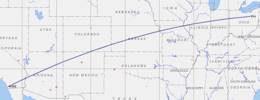
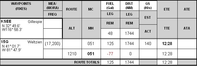
And the flight plan would come out something like this:
Instead, we get this monstrosity:

And this ridiculous flight plan:

The upside is that the extra couple of hours will help MS and the IFR Pilot whittle away at the 10 hours of dual instruction required by the Insurance Gods. And maybe the IFR Pilot can count one of the legs as the commercial cross-country with CFI.
Clearly, we're going to play this all by ear and we'll see how much Mother Nature wants to cooperate. We really want CAVU -- or at least good VFR -- conditions until we are east of the Rockies. We have all of the low altitude en route charts and an entire country's worth of approach plates on DVD (with a battery powered printer, no less), so if we have to go IFR for all or part of the trip, that's doable. But not necessarily advisable, with three people in an airplane with which none will be all that familiar.
We taking suggestions, comments, and observations on the route planning, especially the leg leaving the Vegas area to our next fuel stop. Ideally, legs of two to three hours. That way we get a chance to use the facilities, switch pilots, etc. Your suggestions appreciated. Also, if you've got ideas as to kewl airports for us to stop at, pipe up. Especially if you know of cheap avgas, defined for our purposes today as anything under $4.00/gal.
On a completely separate note, JS passed his instrument checkride today in 78S. Way to go Bro! First round's on me when we get home!!!
No comments:
Post a Comment